Hi all,
I wanted to star off by saying that I have posted very little in the forum. Mainly I read and learn from all of your vast experiences.
This year, we were scheduled to take our family vacation out west to visit some of the big national parks. Unfortunately, my wifes job had some staffing issues that caused her employer to deny part of her vacation time. This meant we would have to choose a destination closer to our home. The KOA at the Outer Banks has been our go to campsite for the last few years because it is super family oriented and allows us to camp virtually on the beach.
We back in our travel trailer to the dunes and unload our comfy camping chairs for a week of excitement and relaxation.
Prior to summer arriving for us, we heard on the news that one of our favorite locations had a new addition. Cape Point(Diamond Shoals), had a new island form virtually overnight. This is not unusual, as the first time I was there in 1998, there was an island about 200 yards off the point in the ocean. The unique feature about this one is that it is a few miles long and a few hundred feet long.
I was more excited that the National Park Service had lifted their driving ban on that location which is typically closed for the migratory birds reproductive season. Not this year!
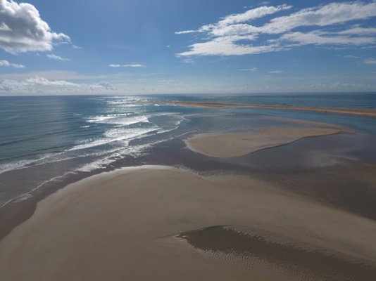
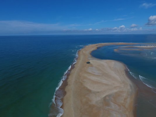
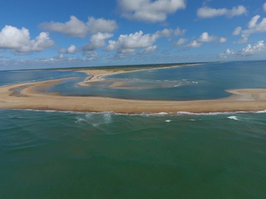
This is an aerial photo of the island that I took while at the point. This is an amazing scene of two opposing ocean currents crashing into each other, depositing the sediment and sand that they are carrying right at the point.
I know that this island, Shelly Island, will also either be consumed by the currents or become part of the point. We made two trips there during our week in the Outer Banks and it is evident that the island is still in a dynamic state of flux. In between our visits was a rather violent storm that quickly changed the geography and locations of the sand bars. All pictures and videos I took were at almost the identical times in the morning at the same tide levels.
I am attaching a few aerial photos. I placed my beach driving videos and drone videos on my YouTube channel if you would like to see more. I am a science teacher by trade and want to share this beautiful act of mother nature with as many people as possible. Tomorrow at some point I will be posting the second video, after the storm so everyone can see how fast it is changing.
https://www.youtube.com/watch?v=dr0tc_7Hpk0&feature=youtu.be
Best wishes,
I wanted to star off by saying that I have posted very little in the forum. Mainly I read and learn from all of your vast experiences.
This year, we were scheduled to take our family vacation out west to visit some of the big national parks. Unfortunately, my wifes job had some staffing issues that caused her employer to deny part of her vacation time. This meant we would have to choose a destination closer to our home. The KOA at the Outer Banks has been our go to campsite for the last few years because it is super family oriented and allows us to camp virtually on the beach.
We back in our travel trailer to the dunes and unload our comfy camping chairs for a week of excitement and relaxation.
Prior to summer arriving for us, we heard on the news that one of our favorite locations had a new addition. Cape Point(Diamond Shoals), had a new island form virtually overnight. This is not unusual, as the first time I was there in 1998, there was an island about 200 yards off the point in the ocean. The unique feature about this one is that it is a few miles long and a few hundred feet long.
I was more excited that the National Park Service had lifted their driving ban on that location which is typically closed for the migratory birds reproductive season. Not this year!
This is an aerial photo of the island that I took while at the point. This is an amazing scene of two opposing ocean currents crashing into each other, depositing the sediment and sand that they are carrying right at the point.
I know that this island, Shelly Island, will also either be consumed by the currents or become part of the point. We made two trips there during our week in the Outer Banks and it is evident that the island is still in a dynamic state of flux. In between our visits was a rather violent storm that quickly changed the geography and locations of the sand bars. All pictures and videos I took were at almost the identical times in the morning at the same tide levels.
I am attaching a few aerial photos. I placed my beach driving videos and drone videos on my YouTube channel if you would like to see more. I am a science teacher by trade and want to share this beautiful act of mother nature with as many people as possible. Tomorrow at some point I will be posting the second video, after the storm so everyone can see how fast it is changing.
https://www.youtube.com/watch?v=dr0tc_7Hpk0&feature=youtu.be
Best wishes,
")