AStravelers
Well-known member
Real Time and History Weather for National Parks and other areas
Towards the bottom of this posting is a link to weather for very specific locations and directions on how to use the website. If you want to skip all my lead in verbiage, just scroll down.
So much of the time I see postings in forums where people ask about certain places to stay in the off seasons, and there are many replies like, ?Oh, no, it is winter time and the weather will be absolutely freezing cold with constant snow, etc.? However when you really view the 30 day history, the weather may actually be find for many people.
We travel a lot in the shoulder seasons and winter. It is so great to be able to visit places and not have hordes of people around and campsites available.
To do this we want to have specific weather history for the exact places we want to visit. Places like Zion NP, Grand Canyon NP, Big Bend NP and many others.
However entering a place name in most weather forecast websites, such as http://www.weather.gov/, https://weather.com/, https://www.wunderground.com/, etc, gives you the weather many miles away. Sometimes 50-100 miles and a difference in hundreds to a thousand or more feet in elevation.
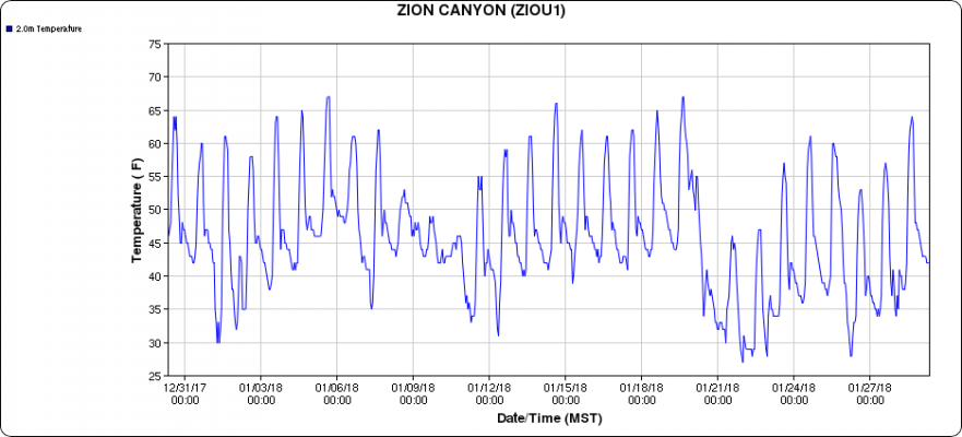
An excellent example is Zion NP. Entering ?Zion National Park? in weather websites has given us the weather in Cedar City, Knab, or Hurricane. Hurricane is not so bad, it is not that far away. The the other two have much colder weather than Zion.
Here is a graph of the last 30 days of weather, right at the campground in Zion we would be staying at:
OK, the forum won't let me put the image here. Scroll to the bottom for the image.
Most days of highs in the 60?s with lows in the 40?s, with bright warm sun, is very pleasant weather. Yes there are a few days of cold unpleasant weather, which we could just wait out, or leave, or not go if the weather forecast is predicting a winter storm coming. Farther down will be info on how to find this info.
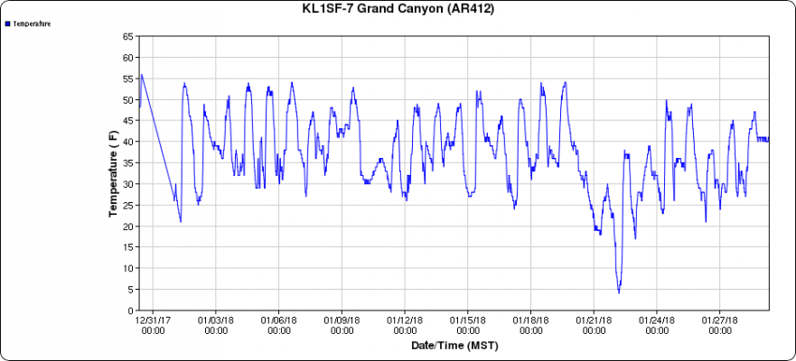
Another example: Grand Canyon NP. Down right chilly weather, but very doable with highs around 50 and lows around freezing, except for a 2-3 days of very cold temps. We have been here in winter with weather like this. It is chilly, but with bright sun, it is quite pleasant.
OK, the forum won't let me put the image here. Scroll to the bottom for the image.
Granted it won?t give us the potential weather extremes, such as if a winter storm comes through. We use the area weather forecasts to watch for weather extremes and leave if we believe the weather will be worse than what we will tolerate for a few days.
OK, enough of the talk!
Here is the link to Mesowest website where you will find locations to thousands of weather stations with exact GPS locations so you can verify you are seeing the weather where you want to visit and not some place 50 miles away and a thousand feet in elevation difference.
How to locate Mesowest Weather Stations
1. Go to: http://mesowest.utah.edu/
2. Click on the state you want. You will see a few black dots with red numbers in white boxes. Each is a real time weather station with current & history data for up to the last 30 days.
Don?t stop here, go to the next step to see all the weather stations available.
3. In the ?Data Selection? area on the left side of the screen, in the ?Network area:? click on the drop down arrow and select ?all networks? and click on ?Refresh Map?
4. You should be seeing all the weather stations available.
5. Look for the ?+ and - symbols? in the lower left of the screen. These let you zoom the map in and out.
6. To scroll the map, use your mouse and ?left click and hold? a point on the map. Now moving your mouse will scroll the map to the section of the map you are interested in.
7. Zoom in closer and scroll the map to the area you are interested in.
8. Click on any black bullet, each of which is a real time weather station.
9. This will bring up a box labeled ?Current Stations Observations?. You are now looking at the last 24 hour readings for that weather station.
10. To look at the history readings for up to the last 30 days, click on ?Additional Tabular and Graphical Displays? located at the bottom center of the box.
(Note: I like to right click on ?Additional Tabular and Graphical Displays? and then select ?Open in a new Tab or Window?. This way I keep the tab or window I was on in my browser so can easily to back to the screen I came from)
11. You should now be looking at detailed info for the last 24 hours
12. To see the history data, click on ?Change to Graphical Display? on the left side of the screen about half way down. This will bring up as screen with the last 24 hours of data in graphical display format.
13. To view the 2, 5, 7, 14, or 30 day history, click on ?Time Period [Previous 1 day] drop down arrow? and from the drop down list select the time period you want and then click on ?Change Graph? (located one line down, all the way to the right)
Towards the bottom of this posting is a link to weather for very specific locations and directions on how to use the website. If you want to skip all my lead in verbiage, just scroll down.
So much of the time I see postings in forums where people ask about certain places to stay in the off seasons, and there are many replies like, ?Oh, no, it is winter time and the weather will be absolutely freezing cold with constant snow, etc.? However when you really view the 30 day history, the weather may actually be find for many people.
We travel a lot in the shoulder seasons and winter. It is so great to be able to visit places and not have hordes of people around and campsites available.
To do this we want to have specific weather history for the exact places we want to visit. Places like Zion NP, Grand Canyon NP, Big Bend NP and many others.
However entering a place name in most weather forecast websites, such as http://www.weather.gov/, https://weather.com/, https://www.wunderground.com/, etc, gives you the weather many miles away. Sometimes 50-100 miles and a difference in hundreds to a thousand or more feet in elevation.
An excellent example is Zion NP. Entering ?Zion National Park? in weather websites has given us the weather in Cedar City, Knab, or Hurricane. Hurricane is not so bad, it is not that far away. The the other two have much colder weather than Zion.
Here is a graph of the last 30 days of weather, right at the campground in Zion we would be staying at:
OK, the forum won't let me put the image here. Scroll to the bottom for the image.
Most days of highs in the 60?s with lows in the 40?s, with bright warm sun, is very pleasant weather. Yes there are a few days of cold unpleasant weather, which we could just wait out, or leave, or not go if the weather forecast is predicting a winter storm coming. Farther down will be info on how to find this info.
Another example: Grand Canyon NP. Down right chilly weather, but very doable with highs around 50 and lows around freezing, except for a 2-3 days of very cold temps. We have been here in winter with weather like this. It is chilly, but with bright sun, it is quite pleasant.
OK, the forum won't let me put the image here. Scroll to the bottom for the image.
Granted it won?t give us the potential weather extremes, such as if a winter storm comes through. We use the area weather forecasts to watch for weather extremes and leave if we believe the weather will be worse than what we will tolerate for a few days.
OK, enough of the talk!
Here is the link to Mesowest website where you will find locations to thousands of weather stations with exact GPS locations so you can verify you are seeing the weather where you want to visit and not some place 50 miles away and a thousand feet in elevation difference.
How to locate Mesowest Weather Stations
1. Go to: http://mesowest.utah.edu/
2. Click on the state you want. You will see a few black dots with red numbers in white boxes. Each is a real time weather station with current & history data for up to the last 30 days.
Don?t stop here, go to the next step to see all the weather stations available.
3. In the ?Data Selection? area on the left side of the screen, in the ?Network area:? click on the drop down arrow and select ?all networks? and click on ?Refresh Map?
4. You should be seeing all the weather stations available.
5. Look for the ?+ and - symbols? in the lower left of the screen. These let you zoom the map in and out.
6. To scroll the map, use your mouse and ?left click and hold? a point on the map. Now moving your mouse will scroll the map to the section of the map you are interested in.
7. Zoom in closer and scroll the map to the area you are interested in.
8. Click on any black bullet, each of which is a real time weather station.
9. This will bring up a box labeled ?Current Stations Observations?. You are now looking at the last 24 hour readings for that weather station.
10. To look at the history readings for up to the last 30 days, click on ?Additional Tabular and Graphical Displays? located at the bottom center of the box.
(Note: I like to right click on ?Additional Tabular and Graphical Displays? and then select ?Open in a new Tab or Window?. This way I keep the tab or window I was on in my browser so can easily to back to the screen I came from)
11. You should now be looking at detailed info for the last 24 hours
12. To see the history data, click on ?Change to Graphical Display? on the left side of the screen about half way down. This will bring up as screen with the last 24 hours of data in graphical display format.
13. To view the 2, 5, 7, 14, or 30 day history, click on ?Time Period [Previous 1 day] drop down arrow? and from the drop down list select the time period you want and then click on ?Change Graph? (located one line down, all the way to the right)