First "big" Tour in our MH

The friendliest place on the web for anyone with an RV or an interest in RVing!
If you have answers, please help by responding to the unanswered posts.

phil-t

Well-known member
Joined
Jul 10, 2017
Posts
1,836
Location
Ogdensburg, NY
Good morning everyone.  We are pretty new to traveling in a class A MH.  Both recently retired and in decent health (wife from Elementary School Librarian and me from Network Infrastructure Manager at a University).
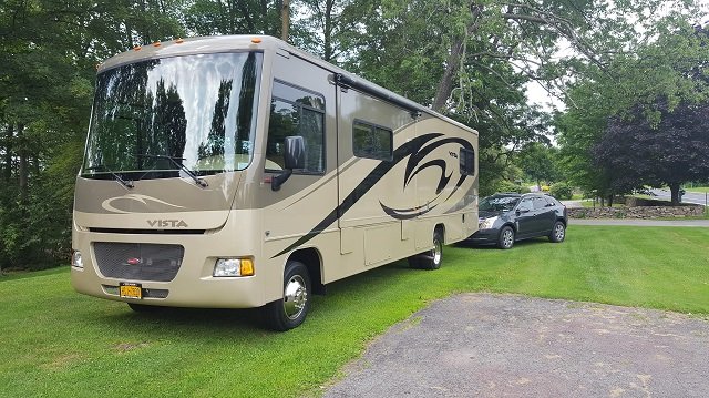
Bought a 2010 Winnebago Vista 32k (2009 Ford F53 22k Chassis with all the suspension add-ons/upgrades) including a RoadMaster tow and brake system for our 2014 SRX toad, last July.  We did a couple small trips, one to SC (2k miles round trip) and one to Maine (1k miles round trip); both visiiting our kids and grandkids.  We really enjoyed the traveling and exploring. I've learned a lot about MH systems in the last few months, both by experience and reading this and other forums.  Feel I have a pretty good understanding of the systems and how they work/operate.
We are planning a 6k+ mile trip this summer (mid-May to early August) traveling a route from home in northern NY to SC, across the south to the GC South Rim, on to Las Vegas, back through NV State Park, Valley of Fire, to the GC North Rim, the Utah "big five", to CO and RMNP, then meandering back East and home. 
We lived in Vegas for a few years, back in the early 70s and have driven the east/west route across I40 and NE to home a couple times. 
My biggest concern in the MH (with toad) is what route from GCNR and Utah Big 5 North to RMNP?  Don't really know what that route may hold for roads, inclines and declines.
We have experienced the hills/mountains in the Adirondacks and the Smokie Mtns. of NC/SC.  The inclines there did not really bother me, nor does traveling 2-lane hiways that are decent for a MH.

We are planning on ~200 miles/day (average) with lots of time for exploring and visiting new places as we park for some time and use the toad for the exploring, new to us, places across the country.  Hoping the 10 weeks will be enough.

I've been doing a lot of prep work on the MH (parked in our garage for the winter).  New batteries, tires, alignment, weight for tire pressure (last fall while loaded), new updated converter/charger, regular maintenance items (oil, filters, lube, etc.) feeling pretty good about the condition and operation of this MH for the adventure/trip.  We are GS members with Roadside Assist and all the other GS Elite Member goodies.  Not sure the GS thing was a financially sound decision; but it gives us peace of mind.  We have used the RA and extended service plan (with tire coverage) a couple times and it seemed very easy and beneficial.

Thanks for all the help I get from reading these forums.
 

Attachments

  • 2010vista.jpg
    2010vista.jpg
    142.2 KB · Views: 69
What a beautiful rig. It looks like you have all your ducks in a row and are ready for quite an adventure. I have a lot of experience camping in the big 5 and most of the other parks in the west so if you have any questions fire away.
 
Thanks, Tom.  I've read a lot of your posts, with interest.  A lot of good info and your photography is excellent and professional.
If you have any kind of recommendations for campgropunds and ways to visit the "big 5" in Utah; and the best way to get to north of Denver for a visit to RMNP from the East, it would be a great help.  We have the ability to "dry camp" for 3 or 4 days (in comfort), if it is a better way than full service campgrounds.  Just need a laundry, water and dump every few days.  Don't mind parking and using the toad for the exploring.
 
Thank you for those kind words Phil.

At the Grand Canyon you can always camp for free in the forests around the canyon. The best one is located about a mile south of the south entrance less than a 1/4 mile after you leave Tusayan. It is called Long Jim Road and it turns off to the left. Drive one fourth of a mile down the road and camp anywhere. Mather Campground has pay showers and a laundromat plus a general store with everything you would need that has the words Grand Canyon written on it.

Zion has full hookups in Watchman but they need to be reserved a few months in advance. South campground does not take reservations. It is very easy to get a spot there as many people leave in the morning. Just be there and drive around till you find an empty site.

At Bryce I love Ruby's Inn and there is a shuttle that takes you into the park. No need for a car in the summer as both the Grand Canyon, Zion and Bryce have free shuttles. If you just want to dry camp finding a spot at North Campground is easy, just be there early.

At Capitol Reef a very good friend of mine is the Superintendent, Lori Rome. If you see her tell her hi for me. Fruita Campground is also easy to find a stop. There are fruit trees close by, hence the name Fruita. And while most people think it is illegal to take anything or pick anything in a National Park, they are wrong. Fruits can be picked from the trees and taken as well as mushrooms and berries.

The Devils Garden campground at Arches is a real pain to get a site in the winter. You gotta get there early and stand in line. They do take reservations in the summer and that is necessary.

Canyonlands is usually easy to get into.

Are you ready for this much beauty? You are visiting a bunch of the most beautiful places in the country. What are your interests? History, nature, hiking, photography? Let me know and I will make some recommendations.

The best way to get from Denver to the park is head north on I-25 and then go west on 66, then north on 36 to Estes Park. There are RV parks in Estes and campgrounds without hookups inside the park. Watch for desert big horn sheep along the highway into the park. The climb the mountains right near the road and are great entertainment.
 
Thanks Tom, A big help.  I saw the canyon from the south and north rims back in '72 when I was stationed at Nellis AFB.  No crowds, much, at that time. I'm sure things have changed.  As far as getting our fill of beauty - that's my plan.  My wife has never seen the western mountains.  I was also stationed in Denver for a few months and saw some of the rockies at that time.
Interests - short 1-2 mile easy hikes are OK, history and will be doing some photogarphy (amaturewith a Google Pixel 2).  Also have a drone that is very capable but asume unusable/not allowed in those parks?  My wife loves to browse and shop while I just watch what goes on around me.  We plan to take advantage of those shuttles.
As far as travel, I was more asking the best way to get from the "big 5" north to Denver, driving a rig like ours.  Don't know those roads and routes at all.
 
Hard to give specific advice without knowing which Utah park you will be before heading to RMNP. Basically you have to get to I-70. I-70 is really a lovely drive itself. Take time to stop at the rest areas and small town along the way to enjoy the views. Going through Denver on I-25 is a pain because of traffic, but it is doable during non-rush hour. You can also take US 40 to the west entrance of RMNP. It is a much slower, very wiggly mountain road, but it is fine for mountain drivers in a rig your size. You should know your comfort level by that time in your trip. The bigger issue is that you would have to climb over Trail Ridge summit with the motorhome, a steep haul. I actually prefer the views on US-40, but there is no question that it is much slower and more challenging than just handling Denver on I-25. You don?t have to decide yet unless you want a reservation in the park itself.
 
I agree with UTT. I-70 is your best bet. It is steep and high, but you must cross the Rockies somewhere to get to Denver.
phil-t said:
Interests - short 1-2 mile easy hikes are OK, history and will be doing some photography (amateur with a Google Pixel 2).  Also have a drone that is very capable but assume unusable/not allowed in those parks?  My wife loves to browse and shop while I just watch what goes on around me.  We plan to take advantage of those shuttles.
Congrats on picking the right camera. The very best advise I can give you about the Grand Canyon and Bryce is to get the heck off the rim occasionally. If you think they are beautiful from the rim just wait till you descend into them. At the Grand Canyon there is a trail called Bright Angel. It is the one the famous mules use. Hike down for not more than 1 and a half miles to the first rest house and then return. Start really early in the morning. Take a lot of water and be out of the canyon by 10am. The rim trail is perfectly flat and sensational. Take the Orange shuttle to Pipe Creek Vista and hike west towards the village. There are plenty of places where you can get back to the shuttle to make it a shorter hike. It is paved all the way. At Zion there are a few short hikes that are exceptional like Emerald Pools. Take the shuttle to the end at Sinawava and hike the Riverwalk Trail. If possible hike the Narrows. That is one of the best hikes in the world. My all time favorite. Check out some YouTube videos. At Bryce there are several trails that head into the canyon and all are spectacular.

As far as history goes, at the Grand Canyon be sure to stop in the East Rim section and maybe camp there one night. The Desert Watchtower is stunning.
 

Attachments

  • All Along the Watchtower (1).jpg
    All Along the Watchtower (1).jpg
    214.3 KB · Views: 15
SeilerBird said:
The very best advise I can give you about the Grand Canyon and Bryce is to get the heck off the rim occasionally.

* * *

If possible hike the Narrows. That is one of the best hikes in the world. My all time favorite. Check out some YouTube videos. At Bryce there are several trails that head into the canyon and all are spectacular.

Two pieces of sage advice from Tom.  When I see friends on facebook saying they are going to the GC, I always tell them to take a hike at least a little ways down into the canyon.  They never seem to listen.  ("Oh, we didn't have enough time")  Probably 95% of the people that visit the GC just drive up, look out over the edge, take some pictures and leave.

Re: Zion, definitely hike the Narrows if you are able.  It was the highlight of our Utah trip. 

Re:  Places to stay in UT, we booked stays in state parks that were near the NPs.  At Arches we stayed at Dead Horse Point SP.  Amazing views out over Canyonlands NP.  It's just like being at the GC without any of the people.  (and there are no trails to hike down into the canyon; just shear cliffs)  At Bryce, we stayed at Kodachrome Basin SP, about 20 miles east.  Tom's right about Ruby's being a convenient option, but we wanted a little more seclusion and it worked out great.  However, the state parks in UT book up as fast or faster than the NPs (in part because they often have nicer facilities).  Reservations are a must during peak season.
 
I have been given the get off the rim advice to many people over the years and most of them follow my advice. I tell them that what you see on the rim is beautiful but it is like looking at a post card. When you hike into the canyon the canyon is no longer a distant sight, you are part of the canyon. It is above you, below you and 360 degrees all around you. The north rim gets closer as you descend and the view gets clearer. There are always fires on the north rim putting smoke in the air making the view from the rim slightly cloudy. Inside the canyon you are below the smoke and the north rim becomes so much closer and clearer. When you hike the Bright Angel Trail just a short way down you pass through a short tunnel and after you pass through it stop and look up to the left and see some 1000 year old Indian pictographs. Check out the Grand Canyon photos in my signature to see these. Also when you hike into the canyon you dramatically increase your chances to see wildlife. There are big horn sheep and other wild animals down there, nothing to be scared of though.
 
Absolutely!  When we went, we hiked down the South Kaibab Trail, IIRC, as well as one that's further to the west of the main complex.  (Can't remember the name)  The initial descent down the switchbacks is memorable in and of itself.  It's been 12 years and I really want to go back soon.
 
jagnweiner said:
Absolutely!  When we went, we hiked down the South Kaibab Trail, IIRC, as well as one that's further to the west of the main complex.  (Can't remember the name)  The initial descent down the switchbacks is memorable in and of itself.  It's been 12 years and I really want to go back soon.
South Kaibab is east of the village and is just as spectacular as Bright Angel. I always recommend BA because of the Indian artifacts, but both trails will knock your socks off. The SK trail has a spot called Oh Ahh Point. There is no sign saying Oh Ahh Point, however all the people standing there looking out will be saying "Oh Ahh". The two trails are as different as night and day. BA is in a deep canyon and the east west views of the canyon are limited. SK is on a fin and stick out into the canyon for superb east west views, especially at Oh Ahh. When taking the SK it is best to go one and a half miles to Cedar Ridge, use the outhouse and then go back up. See the photo below for the view from Cedar Ridge.

One day I met a young couple from New Jersey and while talking to them he mentioned he was going to hike down to the river and back the next day. I spent an hour trying to talk him out of the idea. I don't know if he followed my advice or not. If he did not follow my advice he would end up being one of the more than 250 people that have to be rescued from the canyon every year. It is so easy to hike down into the canyon. You can run all the way if you wish. However hiking out is like being on a stairmaster for eight straight hours in 110 degree weather. A flatlander would never make it. You need at least a week just to become conditioned to the altitude. The cost a helicopter ride out of the canyon is $3000 (or at least it was ten years ago) and that doesn't include a doctor. When the helicopter arrives they ask for your credit card first. So while it is the best thing you can do at the canyon it is best to limit yourself to one and a half miles.
 
SeilerBird said:
South Kaibab is east of the village and is just as spectacular as Bright Angel.

Right.  I didn't mean to imply that SK was west of the village; it is the other trail that was to the west, and upon checking a map it was Hermit's rest.  Not as spectacular, but interesting nonetheless.  On our South Kaibab hike, it was a windy day in February and we had three kids, the youngest about 6 yrs old.  We were headed out toward Ooh-Aah Point, but only went part way out.  We met people coming back up and they said "hold on to your kids when you get out on the point or they'll blow right off!"  It was really strong wind.  Nonetheless, a memorable experience.
 
Hermit's Rest is a very cool place to visit. You can hike there by hiking the rim trail from the village but I do not recommend that part of the trail. It is not paved and there are some pretty severe drop offs next to the trail. Your kids would not have been blown off if they stayed on the trail, only if they would have left the trail and attempted to get as far out on Ooh Aah point as possible. Experienced hikers like to hike down the SK trail and up the BA trail since BA is not as steep so it is the easier ascent. When hiking either trail don't step in pools of water. It is not water. Mules use those trails. ??? There is a trail into the canyon at HR but I don't recommend it since it is really steep, strenuous and it is not maintained. If you get into trouble there are no rangers patrolling it like at BA and SK.
 
As far as travel, I was more asking the best way to get from the "big 5" north to Denver, driving a rig like ours.  Don't know those roads and routes at all.

As Pam indicated, you basically need to get to I-70 in Utah, then head east. Make sure tires and brakes are in good order, since you'll be hitting some 5%-7% grades along there, but it's otherwise nice road. Approaching RNMP from the west (through Grand Lake on U.S. 34) is fine in a car, but I'd be leery of Trail Ridge Road in a motorhome -- there are some tight squiggles, some moderately steep grades, and places where the distance from the edge of the pavement to a steep drop-off is rather minimal, and that would be, at best, a nail-biter for me, when in anything much bigger than a pickup.

So I'd consider Denver or Boulder as my starting point for heading to Estes/RMNP, then to Lyons and U.S. 36 to Estes. CO Hwy 7 from Lyons is a pretty drive, but portions of it might not be quite as comfortable when in a motorhome, though a large part of it is better than US 36 -- it's that last few miles after Allenspark that is not so nice.
 
SeilerBird said:
One day I met a young couple from New Jersey and while talking to them he mentioned he was going to hike down to the river and back the next day. I spent an hour trying to talk him out of the idea. I don't know if he followed my advice or not. If he did not follow my advice he would end up being one of the more than 250 people that have to be rescued from the canyon every year. It is so easy to hike down into the canyon. You can run all the way if you wish. However hiking out is like being on a stairmaster for eight straight hours in 110 degree weather. A flatlander would never make it. You need at least a week just to become conditioned to the altitude. The cost a helicopter ride out of the canyon is $3000 (or at least it was ten years ago) and that doesn't include a doctor. When the helicopter arrives they ask for your credit card first. So while it is the best thing you can do at the canyon it is best to limit yourself to one and a half miles.


Last year at the North Rim, I had a European guy tell me he was going to hike to the river and back...from the North Rim, which is an extra 1500 of elevation you have to deal with over the South Rim.  He looked to be about 65-70, and in pretty fair shape.  I explained about the signs and the heat once you're off the rim and told him to take plenty of water.  He just smiled and explained that he did a lot of hiking and climbing at home in Switzerland, and he'd be okay. 
Not sure what time he left, around 4-4:30am I think.  He was back at his site cooking dinner by 6pm, so I guess he was right.
I did the 5 miles down to Roaring Springs and back when I was in my 20's and it about killed me.  That was back in the day when the Bright Angel Trail used to be on the North Rim.
 
There was a guy who died a few years ago that was something like 80 years old and had hiked some obscene amount of rim to rim to rim hikes. There is a ranger that used to work at Phantom Ranch and she had to hike out to go home. She told me she could make the hike in two and a half hours. She was about 40 at the time and weighed about 90 pounds soaking wet. And she is the all time cutest ranger.
 

Attachments

  • Lori and the Condor.jpg
    Lori and the Condor.jpg
    119.7 KB · Views: 25
There are two routes into RMNP from the east; US 36 through Lyons and US 34 through Loveland.  Both are beautiful drives.  I live in Loveland and so I am partial to taking the Big Thompson Canyon from Loveland up to Estes (US 34).  This route was devastated four years ago in a flood and the entire route has been rebuilt the past two years.  The last of construction will conclude near the end of May and in time for Memorial Day.  If you are planning your trip near or after Memorial Day I would strongly recommend taking the US 34 route through Loveland and up to Estes Park.  The road has been re-enginered and will be all new asphalt.  US 34 follows the Big Thompson river all the way up to Estes. 

Estes Park during the summer season is a nightmare for traffic, especially a big rig.  Most of the commercial parks require you to drive through Estes.  There is a KOA at the east entry point of Estes that allows you to avoid the Estes congestion.  There are several no hookup sites inside of RMNP but reservations are an absolute must. 

Finding a spot to camp in and around Estes/RMNP can be a challenge without reservations.  The trip from Loveland to Estes is about 35 minutes.  Loveland has a few commercial RV parks that you could park the rig in and then take your toad up to Estes for day trips.  If that is a consideration, check out Boyd Lake State Park.  The rates are a little more reasonable and the sites are paved with electric. 

Coming from Utah you might consider taking I80 out of Salt Lake toward Cheyenne.  I80 is not nearly as scenic as I70 BUT it has considerably less traffic and the climb over the continental divide is much less strenuous AND you avoid Denver and the nightmare I25 from Denver north toward RMNP.  If you chose that route you would cut from Laramie on US 287 to Fort Collins and then continue on 287 to Loveland. 

Last comment-RMNP is high altitude.  Many friends and relatives that come and visit experience altitude sickness when visiting RMNP and even Estes.  Drink water and take it slow and easy on your hikes if you are not accustomed to 10,000?+ altitude. 
 
Thanks, again, for all the great comments and recommendations.  We are not able to do any strenuous hikes, so into the canyon and back will be limited to a couple of miles.
Troy, thanks for your ideas; I had been considering parking the rig at a lower campground and using the toad to explore RMNP.  I will consider the I80 and rt 34 ideas, they seem a very good alternative to heavy traffic.  We will likely be at RMNP early to mid July.
Anyone have any good road recommendations for traveling east from the Denver area (other than Interstates)?  Maybe there are some real good US highways that not "big truck" routes?
 
There are two routes into RMNP from the east; US 36 through Lyons and US 34 through Loveland.  Both are beautiful drives.

Ahh -- Big Thompson's been closed so long that I forgot. I didn't know it was opening this year. It might be more comfortable driving a motorhome than US 36. And I-80 would certainly be easier driving for a motorhome, but I didn't mention it because it's a ways further north. Good thoughts.
If you chose that route {I-80} you would cut from Laramie on US 287 to Fort Collins and then continue on 287 to Loveland. 
Or take 80 to Cheyenne then down I-25 to Loveland, though that adds more time/distance.

Another campground in the Loveland area is the Riverside RV Park on the west side of Loveland, just about the the entrance to the canyon -- they opened again last year. It's also near the Dam Store.

And yes, reservations near Estes and RMNP are a must. Boyd Lake on weekends will likely also require reservations, probably six months early (that's the earliest you can reserve), but Sun. through Thurs. nights may have short notice or even drop-in sites available. BTW, that's pretty much true of all Colorado State Parks.
 
I'll be watching this thread with interest!    We have planned our first real trip in our new to us MH for this summer, as I'm retiring in June. Funny, my wife made me promise we would drive right by the GC.  (she is deathly afraid of heights.  I know how to pick my battles, after 36 years with her  ;D )

Starting in San Diego, headed for Sturgis, then Yellowstone, then Western Montana.  Gonna spend a few days in each of those. Then, (due to our traveling companions in 2 other MH's having to return to their jobs), heading to Minnesota to see friends.  Then down to Ohio to see family.   

Then, if we are still speaking to one another, headed over to the east coast (NC and FL) to see friends before coming back across on the lower route, with a stop over in NM.

We did the GS thing too........mostly, for peace of mind. Hopefully, I'll be checking in regularly to post updates and provide current intel on anything worth reporting. :)
 
Back
Top Bottom