Dougie Brown
Well-known member
We're happy to be back in the US after a year back home in the UK. Since 2011, we've visited 6 months out of each year, travelled many miles (and kilometers in Canada ") ) and visited some truly amazing places. Usually, we're here January to June but this year, it's May to November as we're heading for Alaska (from Wisconsin) in convoy with our great friends and their 5th wheeler, ending up in.... Arizona.
) and visited some truly amazing places. Usually, we're here January to June but this year, it's May to November as we're heading for Alaska (from Wisconsin) in convoy with our great friends and their 5th wheeler, ending up in.... Arizona.
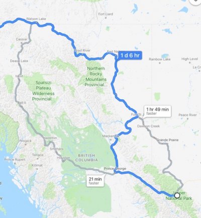
What's the consensus please regarding routing from Jasper, AB? We've been a little ways up the scenic route before from Hinton but know nothing of its condition further north. We've also been west out of Jasper on the Yellowhead (16) heading for Whistler but again, never north. My feeling is 16 to Prince George, then north all the way up the 97 Alaska Highway, but I'm interested in knowing what the 16's like up to Dease Lake before joining the 97 that way?
See map below.
Thanks,
Dougie.
) and visited some truly amazing places. Usually, we're here January to June but this year, it's May to November as we're heading for Alaska (from Wisconsin) in convoy with our great friends and their 5th wheeler, ending up in.... Arizona. What's the consensus please regarding routing from Jasper, AB? We've been a little ways up the scenic route before from Hinton but know nothing of its condition further north. We've also been west out of Jasper on the Yellowhead (16) heading for Whistler but again, never north. My feeling is 16 to Prince George, then north all the way up the 97 Alaska Highway, but I'm interested in knowing what the 16's like up to Dease Lake before joining the 97 that way?
See map below.
Thanks,
Dougie.