West to East through Houston, TX?

The friendliest place on the web for anyone with an RV or an interest in RVing!
If you have answers, please help by responding to the unanswered posts.
jymbee said:
Got it. I'll keep that route in mind.

Last year when we came across this area we we took the more local southern route along 82. That was very enjoyable given for a large part of the route we were right next to the water. The two ferry rides were also pretty cool.

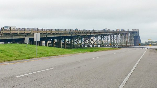
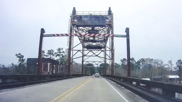
I can't remember at all exactly where we were but at one point we were driving along and his huge "hill" rose up ahead of us out of nowhere! It was crossing a waterway of some kind but it was quite an unexpected surprise given the generally FLAT topography all around us. Made for some interesting dashcam video to show our friends from "back North" however.  ;D

If you were down towards the coast, I wonder if you were going up (or down) Hwy 124 and crossing the Intercoastal Waterway.  That bridge is pretty cool, especially if there's some barges going up or down the coast.
 
The tallest one in the area not on I-10 is the Rainbow Bridge in Bridge City, Texas, built in the 1930's, when it was built it was the tallest bridge in the south, it is still the second tallest bridge in Texas with 143 ft vertical clearance (it crosses the Neches river south of Beaumont), 2 lanes, both southbound now that the newer shorter, much less steep Vetrans memorial bridge was built in the 1980's to carry northbound traffic.  For comparison the I-10 bridge across the Calcasieu river is 4 lanes (2 each way) and 135 ft.

Here is a picture of the Rainbow Bridge https://cdn0.wideopencountry.com/wp-content/uploads/2016/04/RainbowBridge_Texas.jpg

I recall dreading driving over that bridge when I was a teenager back when it had 2 way traffic.
 
edjunior said:
If you were down towards the coast, I wonder if you were going up (or down) Hwy 124 and crossing the Intercoastal Waterway.  That bridge is pretty cool, especially if there's some barges going up or down the coast.

Yep, we did go that way as we were headed East through Galveston and up & around 124 to get back to Port Arthur and down to 82 East.
 
Isaac-1 said:
When you go to leave Holbrook park, if you take Hwy 27 down to 379 (Houston River road), down to 378, and go past Sam Houston Jones State park, it will take you around to Hwy 171, which you can take south to I-10 and bypass the bit steep bridges across the Calcasieu river.  This may add 10-15 minutes to your drive time.  There are a couple of sharp corners and deep ditches to watch for, but you should be ok, if you choose to go that way.  (this is also the back way around that locals use if there is a bad accident on the I-10 bridge)

Took a snapshot of that bridge when we passed around under it to get to the visitor center.
 

Attachments

  • bridge.jpg
    bridge.jpg
    96.6 KB · Views: 14
Yep, that is the I-10 bridge facing toward the Westlake side of the river, the alternative route bridges are these two,

This draw bridge near Sam Houston Jones SP

http://bridgehunter.com/photos/28/42/284206-M.jpg

and the Hwy 171 bridge which is a divided causeway with a hump at one end that allows barge traffic to pass that is so insignificant that I can't find a good online picture.
 
Isaac-1 said:
Yep, that is the I-10 bridge seen from the Westlake side of the river, the alternative route bridges are these two,

This draw bridge near Sam Houston Jones SP

http://bridgehunter.com/photos/28/42/284206-M.jpg

and the Hwy 171 bridge which is a divided causeway with a hump at one end that allows barge traffic to pass that is so insignificant that I can't find a good online picture.

Yep, that's a much better picture than the attached frame grab from our Dash Cam video of earlier today.  ;D


Attachments

  • bridge3.jpg
    bridge3.jpg
    99.7 KB · Views: 10
jymbee said:
Took a snapshot of that bridge when we passed around under it to get to the visitor center.
And if you follow that road around the bend and take that first right at the end of the bend, you'll be at the only inland white sand beach between Texas and Florida, which isn't quite as exciting as we expected ?
 
Lol, it was pretty underwhelming, but if anyone asks if we've been to the only inland white sand beach between Texas and Florida, we can all say it isn't one we'll forget! Lol
 
RVMommaTo6 said:
And if you follow that road around the bend and take that first right at the end of the bend, you'll be at the only inland white sand beach between Texas and Florida, which isn't quite as exciting as we expected ?

OR...  ;)  If you stop by the visitor center the friendly, helpful folks there might turn you on to the possibility of taking a self guided tour. We downloaded the app described on the below site and followed along with the audio/video tour. It's GPS enabled and pops up with interesting audio & video of the sites you're at as you travel along.

I've used other tour apps and most were pretty lame but this one is exceptional! Professionally done with information along the way you never would have known about otherwise.

https://www.visitlakecharles.org/creole-nature-trail/attractions/guided-tours/
 
Ah, the creole nature trail, I keep thinking about driving the loop some weekend, as I have not done the full thing in about 15-20 years.  I see part of it all the time though as my sister in law lives just off one end of it.
 

Latest posts

Members online

Forum statistics

Threads
131,929
Posts
1,387,653
Members
137,677
Latest member
automedicmobile
Back
Top Bottom