Seeking Route Advice- Moab Utah to Durango Colorado

The friendliest place on the web for anyone with an RV or an interest in RVing!
If you have answers, please help by responding to the unanswered posts.
X

X-Roughneck

Guest
Hello Board,  Hoping I can get some advice about the Route coming out of Arches National Park Area to Durango Colorado. 

Specifics 32 ft Class C, with a Tow Dolly, surge brake, Mazda CX-5 in tow.  I will be about 52 ft bumper to bumper.

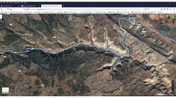
I see the google proposed lower elevation route (See Link below) has the lower elevations Highway 191 thru Monticello, Turning on Highway 491 to Dove Creek, Dolores, Mancos into Durango.  How are the views traveling this route?

Has anyone on this forum taken the LaSal, Ouray, Silverton route?  I see that elevation wise, 11,000 ft.  Not interested in possible June ice and RV mis-adventures. 

I am just a Desert Dweller looking for Adventure, not interested in going on any suicide missions in the RV. 

On another note...Anybody have anything to share about Arches, or Durango, Silverton Areas attractions, Epic Views? 

Me and the Better half love Big Nature!

JD

https://www.google.com/maps/dir/Moab+KOA+Holiday,+3225+South,+US-191,+Moab,+UT+84532/Durango+North+%2F+Riverside+KOA,+13391+Co+Rd+250,+Durango,+CO+81301/@37.5925077,-108.4053445,8.5z/data=!4m14!4m13!1m5!1m1!1s0x8747e30b17696581:0xc5812d7fc66fe35d!2m2!1d-109.4963551!2d38.523874!1m5!1m1!1s0x873ea4d2dc2bd6d7:0xb3ae6962c8e8f737!2m2!1d-107.802055!2d37.453936!3e0
 
Well, I have not done in one pass, the route you want but...

I don?t have an RV yet.

I am an avid long distance motorcyclist. I did ride from from Montrose to Teluride and then to Moab via Naturita. That path was not at all challenging. (Back on 03 when I did it, I was surprised to find easy access to wine and great beer in Moab)

I rode from Durango to Montrose and while the elevations were interesting, the scenic value was outstanding. Ouray, if open, has the the most amazing hot spring bathing facility. Think 3 Olympic sized pools strung together with them from hottest to coolest. Must see. Trains in Durango as a must see for train nuts (like me). Town was pretty dead late in the evening. The DW and I had bar snacks (plus bourbon) for evening meal after arriving late from Chama.
The million dollar highway was not challenging but scenic. We did encounter a hailstorm on the decent to Silverton and while on motorcycles was a concern, not so much on an RV.
 
Co-worker did a trip in 2016 that started in the Black Hills and ended up in Durango (not including the to/from the Atlanta, GA area) and the steam train in Durango is a must.

The Youtube channel Grand Adventure does a very good job of showing you the western US, camping, boondocking, hiking, kayaking, skiing, etc. https://www.youtube.com/channel/UCFbkbLZ1WoWMGkGe7gUw27w/videos

They have several that focus on the Durango and Silverton area.
https://youtu.be/00fKauB3AWQ
https://youtu.be/wte47AEZzwA
https://youtu.be/Uw087seVq_o

Their website http://GrandAdventure.tv has an interactive map that will show you locations and videos for those locations, http://grandadventure.tv/2019/07/28/interactive-episode-map/ When you get to that page ignore the big map on the screen that seems to do nothing and scroll down the screen till you come to the map that you can zoom in and out on and will give you videos when you click on the icons at locations.

Mark has it together on producing interesting videos that inform you without boring you and don't have undue drama, just the facts and information.

Charles
 
While this is just above your request route, the Million Dollar Highway is on our immediate bucket list. Going north from Durango is not as frightening for the first timer then driving south from Ouary . There is also a you tube channel by an 18 wheeler called Riding Shotgun that does that route quite frequently. This is just one of his.

https://www.bing.com/videos/search?q=Riding+shotgun+million+dollar+highway&&view=detail&mid=1F420A44E3E3FE40696D1F420A44E3E3FE40696D&&FORM=VRDGAR&ru=%2Fvideos%2Fsearch%3Fq%3DRiding%2Bshotgun%2Bmillion%2Bdollar%2Bhighway%26%26FORM%3DVDVVXX
>

The steam train in Durango is surely a must too, as has been noted. There is a similar one Chama New Mexico for the train buffs with a campground right along the river to stay. Decent facilities

If you are headed up from Texas, the drive on highway 12 from Bryce canyon east is also a must. There is a couple of areas on 12 that's a bit extreme but not life threatening.  This can take up to 24 and to I 70 and then back down to Moab.

I will add that as you turn off of Hwy 89 to the east and towards Bryce Canyon there is also a decent and easy to get in and out campground called Red Canyon Village about a mile from your turn. 
 
At Arches, be at the gate early, like before 8:00 am. Crowds are horrendous on holidays and weekends, just big the rest of the time. And it gets HOT with temps well into the 100s in the summer. You really do want to have time to walk some of the simple trails to the vistas. Besides, the sunrise views are extraordinary. As for your route, I would do the Mancos one with a trailer. Then take your toad and drive to Ouray one day. Wander as many 4WD roads as you want, but Animas Forks is an easy ride to a fun ghost town. Another day take the train to Silverton. Oh, and Mesa Verde is absolutely a must-see, but take the earliest tours you can manage. It gets HOT there too, plus the drive from the entrance to the ruins is about 45 minutes. We used to visit the areas 5-7 times a year, and we never got bored or thought we had done everything.
 
Thanks for all the input! I got some studying up to do.  Did I say I love RVForum?  Nothing better than words coming from those who have been there, done that, or those who share links to nuggets of Gold.

You can't buy what you can get for free around here.  It is fun to participate...IDKS, but I love to give my opinion, or come here to write long winded replies to stuff I know little about.  ;)

Our Actual Grand Daughter trip is as follows (Ideas welcome to the below areas)  Drift away....and throw me a bone or two.

Start- My Texas Beloved, Chihuahuan Desert
to Carlsbad, NM
to Albuquerque
to Monument Valley
To Grand Canyon (Probably a Bust) and No Red Line / Hermits Road. South Overlook opens 18 May according to web site
to Bryce Utah, Cannonville,
to Arches, Moab Utah
to Durango Colorado
Back to my Beloved Desert.

I will offer up a bit / Free (Grand Canyon) Advice, drifting a bit from my subject line. I like to wander a bit.  When ever the Grand Canyon opens back up the best way to see it is shuttle bus.  Catch the shuttle (park entrance of your ticket is your ticket to the bus, save and bring receipt in your billfold) board the Very 1st shuttle bus in Tusayan (6 Miles South of Grand Canyon, Park in IMAX or at a hotel and go to Main street bus pick up points (Covered Bus stops on the Main Street) Tusayan is a small tourist town, you can not get lost!  Bus into Grand Canyon Main Bus station...Immediately Jump on the Red line (Hermit Road) Best Route which is closed in winter, and you can beat the HUGE crowds later in the day.  Lot's of people get slower starts, so make sure you get on that very first bus.... Unfortunately trying to be a realist, I can't imagine when those buses will come back.  I am not betting in 2020 calendar year, for sure.  Probably won't be until COVID 19 is out of the news cycle. My uneducated guess anyway.  Grand Canyon is one of the world's biggest Tourist Destinations.... who knows where that person crammed in with you in the sardine can/ bus had been 24 hours earlier, Wuhan China, who knows?  It is a shame to have those views go wasted this summer.  Those Beautiful images are burned into my mind forever though.  I sure wanted to show my Grand Daughter.  We are still going to make it EPIC!

We are staying in the KOAs this entire Grand Daughter trip, but will be using the onboard facilities in the RV more than we have in the past to social distance more.

Have fun everybody.  Live your life.  Be street smart, and Go For it!

JD 
 
Boat Addict said:
Going north from Durango is not as frightening for the first timer then driving south from Ouary .

If you are headed up from Texas, the drive on highway 12 from Bryce canyon east is also a must. There is a couple of areas on 12 that's a bit extreme but not life threatening.  This can take up to 24 and to I 70 and then back down to Moab.

I will add that as you turn off of Hwy 89 to the east and towards Bryce Canyon there is also a decent and easy to get in and out campground called Red Canyon Village about a mile from your turn.


BA, Thanks, I am going to check this stuff out. 

I want to take the scary route from Moab Arches thru LaSal, to Ouary into Durango, but at 52 ft, Larry N. already warned me to have my head in the Game as it gets narrow and a bit "hairy" in some spots.  I am hoping I can get somebody to Chime in.  My Winnebago Class C Aspect, feels like driving a Pick Up Truck, so I have not totally ruled it out.

JD 
 
X-Roughneck said:
BA, Thanks, I am going to check this stuff out. 

I want to take the scary route from Moab Arches thru LaSal, to Ouary into Durango, but at 52 ft, Larry N. already warned me to have my head in the Game as it gets narrow and a bit "hairy" in some spots.  I am hoping I can get somebody to Chime in.  My Winnebago Class C Aspect, feels like driving a Pick Up Truck, so I have not totally ruled it out.

JD

Your set up should tow better and handle better than the typical 24 foot TT and pick up truck.  Your pivot point to the back end of your axles  is far less than my pivot point to the axles. And your tow vehicle should be narrower too from your motor home. So as long as you keep your motor home on the road, you should be fine.
 
We have been that way but I will reply tomorrow as I'm in bed now. Lots of suggestions for you.
 
Boat Addict said:
So as long as you keep your motor home on the road, you should be fine.

BA,

A Quote to live by for sure.  ;D  I am thinking I might go for it.  I don't want to put my Grand Daughter in real Danger though.  I did really zoom in and the road looks very interesting / curvy in some spots, but I have some time to sort things out in my mind.

Interested in what Jackie has to say also.  Right now I am hoping for RV driving feedback from somebody that drove the route out of Moab Turning at La Sal following the road south thru Silverton to Durango.  It is way up there, elevation wise, so who knows what the weather could be like? I have learned not to think or take it for granted that everywhere is HOT like Texas all the time.

Does this roads have guard rails on them, seriously I ask?  I remember back in the early 70s my Dad took a wrong turn coming back from our drive from Las Vegas, night time mind you and it took us 5 hours to go 50 miles, old Fleetwood Caddie pulling a Starcraft crank up trailer.  Ice and no guard rails and night driving.  What could be better?  Only joking.  Ahh the memories.  :). I guess safety was optional back then.  Hopefully the road does have guard rails, not that I plan on hitting them, just.....to know they are there, if you catch my drift. ;)

JD


A quick search on you tube shows a time lapse video of Moab to Telluride Colo.

https://www.youtube.com/watch?v=kk7b-fJCLRg
Check this one out.
https://www.youtube.com/watch?v=Y_IXeUN38fE


If you watch the video that I posted from the 18 wheeler, going south the road does not show a lot of guard rails on the northern section to Red Mountain Pass.
 
Ha, Motorhome vs. Guardrail. I can guess the winner.

DW forbids me from taking he Million Dollar Highway with our motorhome.

She refers to it as Dead Mans Highway.

I think it?s drivable, but my fear is a braking failure. If engine/tranny braking quits, the wheel brakes would soon follow with catastrophic results.
 
I have a bumper sticker from the gift shop atop Pike's Peak: Real men don't need guardrails.
 
I have driven both routes, once in a MH with toad and once with 3/4 ton truck and 30' trailer.  In many places there are no guard rails and no where to put them.  The edge of the road is literally the edge.We have driven the route south in a car as well...not nearly as adrenalin pumping when you are in a car.  My wife said I am not allowed on that road ANY more.

Of the two routes, I suggest the route through Delores and Cortez.  Once you arrive at KOA north, disconnect the toad and go to a drive to Silverton and Oury.  We have also visited Teluride, but thought it was way overpriced and too commercial
 
wndopdlr said:
I have driven both routes, once in a MH with toad and once with 3/4 ton truck and 30' trailer.  In many places there are no guard rails and no where to put them.  The edge of the road is literally the edge.We have driven the route south in a car as well...not nearly as adrenalin pumping when you are in a car.  My wife said I am not allowed on that road ANY more.

Of the two routes, I suggest the route through Delores and Cortez.  Once you arrive at KOA north, disconnect the toad and go to a drive to Silverton and Oury.  We have also visited Teluride, but thought it was way overpriced and too commercial

My thoughts also on Teluride. Boring! The DW and I stopped overnight on our way to Moab on motorcycles (we were doing a huge figure 8 starting in Boulder CO and crossed the 8 in Montrose.
 
Both routes are do-able and both beautiful.

Proposed route through Monticello is a nice drive, the quickest with desert views.  I will list things to do below should you want a stop or two on the way.

The road via La Sal is a bit longer with some great views through the Paradox Valley and then through the mountains.  The Paradox Valley is really beautiful drive.  There are petroglyphs along this route if you are interested:

https://www.gjhikes.com/2019/05/paradox-valley-boulder-petroglyphs.html

There is a lot of elevation and although the route from Ouray is steep and windy, it is still a highway. Some reviews on line suggest that it is a challenging drive with one reviewer said he was glad he was not towing a vehicle behind is 32ft RV. One other reviewer said that he saw bigger rigs needing both lanes to turn, and a local saying he had done it with no issues but you must observe the speed limits and stay in your lane.  He said if you use common sense it is a road to be respected but not feared.  Apparently Mountain Directory West does not recommend this route for bigger rigs, however there are NO restrictions on Highway 50 according to the Colorado website:

https://sites.google.com/state.co.us/cotriporgfreight

If you are nervous at all then I am of the opinion that you would not enjoy the drive and be very unlikely to enjoy the views either.  Ultimately there are differing opinions and I think a lot depends on your confidence.  Steve says he would be happy to do that route, we have driven a fair bit in the mountains but so far only done that section by car.  If you are good at using your gears downhill that helps.

So things to do IF you want to have a few stops, which is looking unlikely due to the short distance, but here they are in case you are interested.

Blanding is 20 miles south of Monticello and we stay at a nice RV park there called Blue Mountain RV.  There are lots of things to see in that area.  The Edge of Cedars State Park Museum is small but has great exhibits and is an ancestral Puebloan archaeological site.  Natural Bridges National Monument, Butler Wash Ruins, Bears Ears National Monument are places worth exploring. Muley Point Overlook is beautiful and the Moki Dugway another windy road going down to Mexican Hat not far from there.  the town of Bluff is small but has an old Fort and there are several areas close by to see Petroglyphs.  The area is filled with interesting stuff.

Mule Canyon has a great ruin which is a relatively easy hike to get to called House on Fire, it is just over 2 miles round trip through a little valley crossing over the river a few times.  You need to check on line for directions as there is also a roadside Kiva with a sign for Mule Canyon but this is not the way to that ruin.  There are several other ruins farther down.  If you get there between 10 and 11 it looks like the roof is on fire due to the sunlight.

We stayed at McPhee Reservoir Campground close to Dolores which we absolutely loved as the sky at night was spectacular.  The campsite had a shaded picnic table and nice campfire.  Dolores has a really nice little brewery where you can get a pizza and beer (not sure of rules regarding children).

We visited the Canyon of the Ancients Museum which is large and filled with interesting exhibits.  The actual Monument itself is not close by and most of the ruins are not easy to get to.

From there you can do the beautiful drive from Dolores to Telluride which is a small ski town.  The town itself is nice but nothing overly exciting but the drive there is lovely.

Hovenweep National Monument is an hour from either Blanding or Dolores.  This is a spectacular place to visit with an easy 2 mile hiking trail around the square towers.  Great night skies here too and a campground should you fancy it.

Mesa Verde National Park is 20 miles from Dolores.  It is a spectacular park to visit full of cave dwellings , however, at the moment it is closed so you would need to check situation if you fancied it.

If you have not driven down through Ouray then once you get to Durango you could take a trip up through the mining towns.  We have plans to go back there at some point as both times we have visited it was pouring with rain so we didn't stay long.  Because of that I don't have any trip info to impart.

There is just a huge amount to do in such a small area.  Enjoy your trip no matter what you do.  And drive safely.  :)
 
ChasA said:
I have a bumper sticker from the gift shop atop Pike's Peak: Real men don't need guardrails.

Chas was that next the bumper sticker Real Men Don't Read the Directions, LOL. 
 
Lot to think about and we did watch some YouTube about the Million Dollar Highway last night.  I think I am going to take the easier, less dramatic route and explore the area by Mazda CX-5.  When traveling I am 52' bumper to bumper.  We may not get back up to the Paradox, LaSal area in the car, but it looks like We won't be at a loss for Epic Views coming back out of Durango North KOA up towards Silverton and the surrounding areas.

The intent is to share beautiful places with my Grand Daughter and this trip will accomplish that, no matter what road we take into Durango.

Some of my sway towards my decision is what the board members have shared. 

Is Chas Trying to get me killed,  ;)?  Only joking.

I keep remembering back to a short drive from Rapid City to Badlands NP last year in the motor home.  The gale force winds pushing my rig all over the highway had me exhausted mentally in just over 100 Miles. Could have been compounded by the failed rear shock too?  The edges of that road coming from LaSal to sheer certain death drop are not appealing.  Heaven forbid you had a tire blow out, and traveling South Looks like I would be taking the cliff drop side. 200 miles of this La Sal road, and I might need a drip margarita IV at the end of the day, just to unwind.

Too many distracted drivers now days and those must be factored in.  I am bringing the TOAD for this very reason...Being more nimble to explore.

Also, not being from Mountainous Areas, at that elevation can you get freak ice storms in the summer months?  Asked by Someone who lives in the Hot Desert.
 

Attachments

  • Presentation1.jpg
    Presentation1.jpg
    43.8 KB · Views: 10
jackiemac said:
Both routes are do-able and both beautiful.

There is just a huge amount to do in such a small area.  Enjoy your trip no matter what you do.  And drive safely.  :)

Jackie thanks for the detailed reply, and to the other board members input  :)) :)), two thumbs up.  Lot's to look at and plan for.

Still open to any shared experiences from others on any leg of this route.   

JD
 

Latest posts

Members online

Forum statistics

Threads
131,972
Posts
1,388,452
Members
137,722
Latest member
RoyL57
Back
Top Bottom