Carl (or anyone else) I have a few questions about this: Is your understanding of this correct? (from wikitravel: http://wikitravel.org/en/Yosemite )
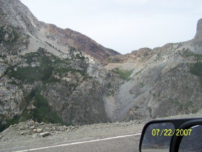
"WARNING: Traffic along State Route 140, one of the main routes into Yosemite from the west, was blocked after a landslide covered the road between El Portal and Mariposa in the Spring of 2006. Bridges have been built to divert traffic around the slide. Traffic is restricted to one lane (total) with opposing traffic held back via cycled traffic lights. Expect 15 minute delays as the lights cycle. Vehicles over 28 feet long are currently prohibited from crossing the bridges. The crossing of the bridge to the opposite side of the Merced River affords a very nice view of this geological event. Traffic leading to Yosemite through this route has been reduced due to the length limit of vehicles and assumptions that the road is closed. Vehicles over 28 feet are finding alternate routes into the park, while those under 28 feet traveling via Mariposa find the lack of large slow-moving vehicles welcome "
But then why does it say this? "State Route 140 is still closed. Highway 140 is now pleasantly less congested and the bridges aford an excellent view of the massive rock slide. "
I am wondering, perhaps State Route 140 is different to HWY 140. Bloomin' confusing to me one way or the other.
There is *nothing* on the nps page: http://www.nps.gov/yose/planyourvisit/driving.htm about 140.
Also, if the limit is 28ft. and my RV is exactly 28 feet am I safe for passage?