Route 66 with an RV???

The friendliest place on the web for anyone with an RV or an interest in RVing!
If you have answers, please help by responding to the unanswered posts.

travelbyrv

Member
Joined
Apr 6, 2008
Posts
9
Location
Manchester, New Hampshire
Hi,
Normally I travel the Route 10 highway from Florida and continue west until I find my way to Yuma, Arizona. I mostly travel the very lower highways from one end of the U.S. to the other. I want to find a new route (to me it's new) to go from east to west. My question is: Do you think that Route 66 is an RV-friendly highway or should I avoid it. If it is worth it, what info (book) should I bring to get the most out of the Route 66 journey?? Thanks in advance!
 
Rt 66 barely exist anymore in some parts of the west - it has been criss-crossed with interstates and newer highways until there are just bits and pieces here and there. You won't even find it on a modern map - that "route" number is no longer in use. You will probably have to buy a map of the old route from a website such as THIS to trace it. You will also find signs in Arizona and New Mexico showing where segments of "Historic Rt 66" still remain.

So no, it really isn't an RV friendly route, but you can find it and travel on parts of it if you try.
 
Route 66 through Oatman, AZ isn't very RV friendly. We chose to take the alternate underground route. See here.
 
We drove Route 66 in 2002 or maybe parts of it.  I think this is all that is about left.
 

Attachments

  • sDSC00439.JPG
    sDSC00439.JPG
    166.6 KB · Views: 59
  • sDSC00463.JPG
    sDSC00463.JPG
    128.7 KB · Views: 52
  • sDSC00464.JPG
    sDSC00464.JPG
    146 KB · Views: 55
One of our members, Pete Harpin, has spent years documenting route 66 in photographs and has a CD with his images.  I don't have a web source for it, but perhaps one of our other members has a reference.  A Google search on pete harpin route 66 will turn up numerous references.
 
Rte 66 ran from Chicago to LA. Doesn't work well from FL. I-20 might provide a little different scenery but it ends at El Paso.
 
RV Roamer said:
Rt 66 barely exist anymore in some parts of the west - it has been criss-crossed with interstates and newer highways until there are just bits and pieces here and there.

As a frequent watcher of the Pixar movie "Cars" (yes I have young kids ;)), that is the exact story told in the movie.  Good flick by the way!  In the DVD special features, the movie's director John Lassater took several months off from work when the film was done - he leisurely traveled Rt. 66 with wife and kids IN THEIR RV to slow life down and enjoy all the unique aspects of the route.  I don't remember exactly what section(s) they traveled, but apparently it can be done to some extent.  In my area of central Illinois, Rt. 66 is certainly a fairly major 2-lane highway that parallels the interstate in most places and goes through every small & big town along the way.
 
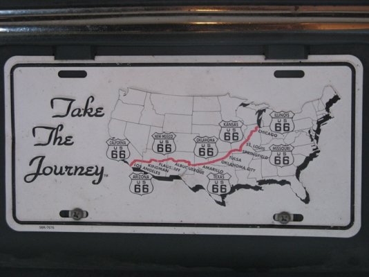
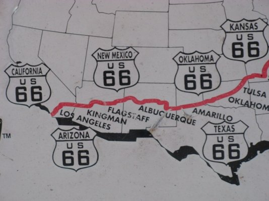
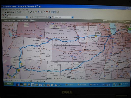
Get the Cars CD.  Then take a look at Arizona State Route 66, from Seligman to Peach Springs and westward to Kingman.  If you're using Microsoft Streets you'll have to zoom in further than the length of the segment for it to appear.  Look familiar?

Seligman most closely resembles the town in the movie and many of the geological formations were borrowed from New Mexico.  The 90 or so mile loop is very driveable in a RV.  Grand Canyon Caverns has a campground and is an interesting undeground cave, accessable by elevator.

Avoid the segment between Kingman and Oatman, over Sitgreaves Pass.  It's about the same as it was in the 1920's, extremely narrow and lots of sharp turns and sudden dropoffs,  but if you're up for adventure you might want to take the toad for a day trip from Laughlin to Oatman, then over the pass to Kingman before returning to the RV via the Interstate.  Oatman is famous for it's "wild" burros, they roam freely and respond well to being fed handfills of feed you can get from gumball machines scattered around town.  The Oatman Hotel is said to be haunted by the ghosts of Clark Gable and Carole Lombard, who spent their honeymoon night there.

Another intact segment is the National Trails Highway, also off of Interstate 40 between Mountain Springs Road and Ludlow.  Along the way you'll pass through the largely but not completely abandoned towns of Amboy and Bagdad (home of the "Bagdad Cafe" from the 1990 movie of the same name).

Although not as thouroughly documented, you can continue west on the National Trails Highway (old Route 66) from Ludlow to Barstow, through town on Main Street, then looping south through Helendale to Victorville.

I've traveled all of this, and it's very do-able in a RV, except as noted for the stretch between Kingman and Oatman.   Most of the road and it's surroundings look like it did when the Interstate bypassed it in the 1960s, and in general the surface is good.  In California, on some of the lesser-traveled segments there are stretches where the underlying concrete slabs are buckling the asphalt, giving a bit of a buck-board ride.  But nothing too outrageous.

Take a look at http://www.theroadwanderer.net/  I highly recommend taking a look at it.
 
In NM, the original route after Tucumcari, goes up to Santa Fe and then down to Albuquerque.

It went straight south to Isletta Pueblo, then it is NM 6 that begins at the jct with NM 47 in NE Los Lunas and heads west for about 35 miles when it begins being occasional segments, some short, some fairly long headed towards Gallup.

As described by Lou, in AZ. there is a long segment of '66W of Williams and Ash Fork from Seligman that goes through Peach Springs on out to Kingman. There's a long valley E of  Kingman where I saw the most and tallest dust devils I've ever seen, one time there were 13 in that stretch and easily went over 1k' in the air. When we lived in Holbrook AZ this was the only way to the grandparents in Laguna Beach and Disney Land.

The time is at hand when a lot of snow could fall in W NM and from E of Flag to W of Seligman.
 
between Kingman and Oatman

Lou,

I have been on that road but did not realize it was Old 66.  Wally and Helaine were with us and we followed a 40' Eagle towing a Hummer and we could not keep up with him.  Don't remember if we met any traffic.
 
WOW!!! - thanks for all the info about Route 66......We will stick to the southern most route that we are more familiar with! :)
And you guys wonder why the RVForum link is on my website www.travelbyrv.com sending traffic over to you all. Just can't find a better Forum about RVing!!!!
Thanks again!
 
We S&T doesn't really give a good looking map.  Sooooooooooo I went out to the front of our van.  Sorry for the Fall Color Bugs.  Got plate in March of 2002 when we drove in that area and along Rt66.
 

Attachments

  • aa Plate.jpg
    aa Plate.jpg
    107.6 KB · Views: 46
  • aa SW Plate.jpg
    aa SW Plate.jpg
    94.4 KB · Views: 39
  • aa NE Plate.jpg
    aa NE Plate.jpg
    115 KB · Views: 34
I dug through our files and here is S&T map from our 2002 trip that included Rt66 as the return route.

Brings back memories.  We went west in March of 2002.  Spent the first night at a KOA just west of Des Moines.  Got in after 7-8pm.  No one there and we were the ONLY ones in the campground.  The only heat source we have is a built-in 1000/1500 watt electric heater (that is why we wanted/needed the KOA).  It was about 20F out that night and THE WINTER WIND across those flat lands was notable.  We were rocked all night long by the wind gusts.  The smalll electric heater proved adequate and the temperature in the van was fine.  The WIND though!!! :eek: :eek: :eek: :eek:
 

Attachments

  • IMG_6517s.jpg
    IMG_6517s.jpg
    219 KB · Views: 47
Great! Thanks for the map Len and Jo! It sure helps alot to see how far up north Route 66 actually starts. I think from everyone's response that I'll be taking a risk with the road and weather looking for what's left of Route 66. Too funny about the license plate Len and Jo! I see what you are talking about those with the weather being that far north in the winter. I just can't take that chance. I was just looking for an alternative road/highway that I could take from New England to Yuma, Arizona and see something different than normally taking the I-95 to I-10 across. Any ideas??
 
Donna, it all depends how much time you have and are willing to use. One thing for certain, you'll have to go South first. Try heading down 95 towards Florida, take as many rural roads as you can to see the scenery. Then head West on 98, following the most southerly route available along the Gulf shore as far as you can go. You will hit US 10 again for a while until you get to TX then follow the shore again towards the Rio Grande Valley and work your way north again until you finally hit NM an AZ.. These back roads are where you really get to see the country. There are some very interesting campgrounds on the way...some great, some terrible.. part of the fun.

  Whatever, we did it and it was an education.
I am sure you know what I am talking about. There is nothing more boring than traveling on the interstates; you can't see a thing.

  Just my 2 cents worth.

carson FL.


carson said:
Try heading down 95 towards Florida, take as many rural roads as you can to see the scenery. Then head West on 98, following the most southerly route available along the Gulf shore as far as you can go. You will hit US 10 again for a while until you get to TX then follow the shore again towards the Rio Grande Valley and work your way north again until you finally hit NM an AZ.
West on 98 will be new to me and so will following the shore again after US 10. I'm sure it's RV Friendly so I'll add it to my map trail as a new way to get to Arizona. Those back roads are so pretty. I remember passing thru Christian Pass in, I think, Mississippi. Wish I remember that name of that two lane road along that beach. THAT was pretty. The beach was on one side and very nice houses on the other side of the road and I remember a Waffle House there too. Gosh, what is the name of that road??
Thanks Carson!
 
Check out www.theroadwanderer.net.  He has a great Rout 66 travelog.  I can recommend leaving I 10 at San Antonio TX and taking US 90 to Del Rio and then to where it re connects to I 10.  See where Judge Roy Bean held court.  This route has much les truck traffic and better scenery than I 10 IMHO.  The ru along the Gulf in Mississsippi was damaged in Katrina.  I don't know how it id now. 
 
travelbyrv said:
I remember passing thru Christian Pass in, I think, Mississippi. Wish I remember that name of that two lane road along that beach. THAT was pretty. The beach was on one side and very nice houses on the other side of the road and I remember a Waffle House there too. Gosh, what is the name of that road??
Thanks Carson!


That would be Pass Christian actually.  On Highway 90.  You could pick up Highway 90 outside of Mobile and run it along the coast of Mississippi, then on over into Louisiana and in to Texas.  90 goes al the way to Van Horn TX, but does either parallel or actually merge into I-10 in a number of places, most notably right through the middle of Houston and San Antonio, but there are lots of places to get off of I-10 and go 90.  Sounds like y'all are in for a great trip!
 

Latest posts

Forum statistics

Threads
131,973
Posts
1,388,468
Members
137,722
Latest member
RoyL57
Back
Top Bottom