North To Alaska

The friendliest place on the web for anyone with an RV or an interest in RVing!
If you have answers, please help by responding to the unanswered posts.
Port Townsend, Port Angeles and the Olympic Peninsula were one of my favorite places. I had friends, Bill and Berry Font, who owned the Conestoga RV Park  for over a decade -it was a good place from which to get to the ferry and Victoria. I was touring Fort Worden in '78 [where and Officer And a Gentleman was filmed,] when a BB Rally drove in, the first time I'd seen more than one Wanderlodge anywhere. And to think I turned down an invitation to come back to Ft. Valley and work with the Luce's building those particular coaches. . . Good decision. Instead, I ended up moving to Omaha in '79 where I met the lady named Bev! Will you be going to Juneau? 
 
Marsha,

We have been fishing the N.Platte in Wyoming, at Grey's Reef. It is an amazing river and I caught two HUGE rainbows with my new Orvis Helios 6 weight rod, and a lot of smaller ones. Life is good as Betty says!

Enjoy your trip to Alaska and bring on the reports.

Marie
 
Marsha:

When we lived in the Seattle area we always tried to get the kids to visit us in July or August (the dry months) but they always said June fit their plans better so they enjoyed the wet NW!
 
On Thursday we drove to Sequim (pronounced Squimm) and Port Angeles.  We have several friends who have talked about retiring in the Sequim area so we wanted to see just what it looked like.  Port Angeles is where the actual Olympic National Park begins.  Sequim looks more like a farming community and is not on the water?s edge.  It felt a bit barren and not exciting to either of us.  Port Angeles is right on the water and is a major port, older town and the hub of business for that part of the peninsula.
We found the visitor?s center for the National park and also found there was a trail where we could take Charlie for a hike.  Off we went about 25 miles further west and finally found the trail.  If I had to describe a rain forest that trail would have met the requirements.  There was moss and lichen everywhere, dripping branches and a complete overhead canopy of trees.  Moss even covered the entire circumference of the trunk of the tree.  The ground was completely covered with what I call ?Boston? ferns.  There were places where little rivulets of water were running from the ground.  The trail followed along the edge of a lake in some places, so it was nice that Charlie could get a drink.  It was cloudy, wet and cool but a great hike.  The most exciting thing we saw was a 2-3 inch yellow banana slug?..(yuck).
On Friday we had no plans so enjoyed a great lunch at the Hudson Point Caf?.  After lunch we took Charlie for a walk about town.  Pt. Townsend is very dog friendly and many stores have water dishes set out for vacationing dogs.  We also learned there was sailing races for the weekend, so sailboats were starting to arrive and fill the small harbor.
.In the afternoon we set out to explore the ferry system and learn just how long it would take to get to the ferry to Seattle and back to the campsite.  Since we were leaving Charlie at the campsite, we wanted to make sure we weren?t leaving him too long.  We drove to Bainbridge Island to the ferry docking site, found places to park and figured out the ferry schedule. 
Saturday was a big day; we left for the ferry, made our connections and arrived in Seattle with sunny skies and big puffy clouds?..oh yippee?.we love the sunshine.  One of the things we wanted to do in downtown Seattle was to go on the Underground Tour?.  Seattle was originally built at water level along the port, so when it rained, everything flooded.  To fix that problem, the city fathers decided to raise the roads and sidewalks up to the second story of the existing buildings.  To accomplish this feat they built 20-30 foot high retaining walls around every block and filled in between the walls to build the streets.  The whole affair looked like a big waffle.  Between the walls and the stores was an area wide enough for a sidewalk.  To get from one side of the street to the other required climbing a ladder to the street level and then climbing back down a ladder on the other side of the street..men were at every corner available to hold the ladders as the women folk climbed up and down the ladders.  There were several serious injuries from people falling off the ladders.  On one occasion a horse fell from the street level onto the pedestrians walking below.  The original city streets, sidewalks and building fronts are still below ground.  The tour lasted over an hour and we heard lots of past ?seedy? stories and lots of history.  For instance the city of Seattle loves to make money.  They took a survey of all the businesses in Seattle with the intention of taxing the most prevalent businesses.  They found out the most prosperous and prevalent business near the waterfront was seamstresses.  There were over 2,500 seamstresses in Seattle..no comment.  Also prior to the raising of the streets large potholes or sinkholes were in every street.  During high tides or heavy rains these holes which were impassable and quite deep (measured in feet not inches) were a danger to the public.  Enterprising individuals provided boats to cross the roads and in one instance a child actually drowned in one of the holes.  The guide pointed out several times that Seattle was always trying to make money but not spend money.  In this instance instead of filling the potholes to prevent further accidents they provided life preservers at each intersection and required all school children to have swimming lessons.  All in all it was a great tour.  Many of the old storefronts were still visible at he bottom of the tunnels and there were many more interesting stories regards the building and growing of Seattle.The second thing we wanted to do if we had time was to visit ?Pike?s Market?.  It?s known for fresh fish and the art of ?throwing? large whole fish across aisles to customers and having a grand old time.  After we finished the tour, we looked at our time and because we were walking 8 blocks to the market and 8 blocks back that we were pushing it, so we caught the ferry home. Pikes market is saved for our next tour.  We left Seattle and arrived home with sunny skies and with calm wind; so we sat out near the water, where we enjoyed ice cold beer and watched cruise ships leave the sound. 
On Sunday, we felt like we really hadn?t seen much of the National park.  It is very densely forested and with all the clouds and fog we have had, we had not seen as much as we wanted.  The interesting part about Olympic NP is that it has a variety of eco systems.  Within the park are two or three designated rain forest ecosystems.    The HOH Rainforest is the most visited part of the park and was about 150 miles, but we decided it was worth the drive. 
The Visitor center was closed when we got there; but there was a small hiking trail so that you could actually walk through the rainforest.  I think both of us were a bit disappointed.  It was pretty, it was interesting; but just didn?t feel like a rain forest.  There was one section call ?The Moss hike?, where large old trees were just covered from head to toe with moss.  This part of the park gets between 140-180 inches of rain per year.  Most interesting was a downed tree from which new trees had rooted and were growing right out of the old trunk.  These were not small trees. 
Our drive back to Port Townsend was uneventful and we were a bit tired when we got there.  The sun came out in the afternoon so that was nice.  Also we stopped for dinner in Port Angeles and relaxed a bit so it broke up the drive.  We are far enough North that daylight lasts until 9:30 PM so we did not think it was that late until we got home..whew, it was a long day.  This was our last night in Port Townsend, tomorrow we head to Bellingham for a 1 night stay getting ready to cross over into Canada.  I told Tim, now I feel like the real adventure begins!!!
The drive to Bellingham was great.  Instead of going back on Highway 101, we took #19 to#101S to#3 to #16.  4 lanes most of the way.  #19 runs right into #5 and we scooted right along.  We haven't done much heavy traffic driving, so that flexed the nerves a bit.  The campground in Bellingham was nice; close sites but leave and easy in/easy out.  I called the border crossing and found there were no surprises in what we could take across the border.  Tim did throw out his bear spray.  Someone had given him a can, so it was no real loss.  We just didn't want the hassle.
Tuesday was again cloudy and drizzly, we drove up highway 539 crossing at Alderwood, BC.  It was very easy.  We were however surprised at the border patrol's questions.  We were used to the do you have any liquor, where are your from, where are you going; but this time they asked if we owned the motor home, were we meeting people in Canada and did we have gifts for anyone.  We answered "yes, no, no" and he said have a great visit.
Oh joy....we are now in Canada, the land of "loonies and twonies" (spelling?)
Marsha~
 

Attachments

  • seattle.JPG
    seattle.JPG
    212.3 KB · Views: 23
  • bananaSlugHike.JPG
    bananaSlugHike.JPG
    413.9 KB · Views: 15
  • HOHrainforest.jpg
    HOHrainforest.jpg
    167.4 KB · Views: 22
  • PortTownsendflowers&cruiseship.jpg
    PortTownsendflowers&cruiseship.jpg
    144.6 KB · Views: 23
  • porttownsendMarsha&Flowers.JPG
    porttownsendMarsha&Flowers.JPG
    217.9 KB · Views: 22
  • undergroundSeattle.JPG
    undergroundSeattle.JPG
    280.5 KB · Views: 24
  • UndergroundSeattle2.JPG
    UndergroundSeattle2.JPG
    246.5 KB · Views: 24
  • UndergroundSeattle3.JPG
    UndergroundSeattle3.JPG
    230.3 KB · Views: 24
Marsha,

It's been many years since we took the Seattle Underground tour and I had forgotten many of the details.  Thanks for reminding me of them.  Isn't it fascinating?

Now that you've passed through Customs you know you're REALLY on your way.  Have a blast!

ArdraF
 
Love reading about your travels. Enjoy your transit of that foreign country :)

Wendy
 
Really enjoyed reading your first travel story, Marsha.  Looking forward to more as you continue your trip.

Margi
 
Marsha, great post.  I've been to Washington several times but not to the Underground.  That's on the bucket list now.  I think you might have enjoyed Sequim more if you knew someone in the area.  We have friends who live on the mountain side of the 101.  They have a spectacular view of the entire Sound and Mount Baker.  We've been there a few times and have probably seen more of Sequim than most visitors.  Still, the town is pretty laid back and not for us.  Port Townsend on the other hand is definitely on our short list if we ever sell the house and leave SoCal.  We've been to Whistler but didn't stay.  It was a few years ago and the area was experiencing some major fires.  Enjoy your trip and keep those great posts coming.

Gary

PS.  hope you left your leak problems back behind.
 
I think it's "loonies and toonies".  Keep at least one quarter and one loonie in your wallet.  You'll need one or the other as a deposit for a grocery store cart at most BC markets.

We're hanging out at Hudson's Hope, waiting for the rain to stop.  We may spend the summer touring northern BC and Alberta instead of driving to Alaska (we've already done that twice).  Weather permitting, we'll go the the International Chainsaw Charving championship tomorrow in Chetwynd.  If you decide to do the Hudson's Hope loop, we're camped in a waterfront spot at the Cameron Lake municipal campground.

Have fun!

Jeannine
 
Jeannie it is "loonies"....at least it was better than what I said to the office at the campground when we got into Canada.  I needed loonies to do laundry and I asked for "onesies".  Only a grandma would come up with that one.  I was so embarrassed, I didn't realize what I said until long after we left the office; but apparently they realized what I needed because they exchanged my US for Canadian loonies.

We are in Williams Lake, BC at the moment and will be heading to Prince Rupert tomorrow, then onto Hyer/Seward.  It's sunny and beautiful here.  From Hyer/Seward we will be taking the Cassiar (37) up into Alaska.  I'm a bit worried about the road. 

Even the locals have been complaining about how much rain and how cold the month of May and June have been.

Marsha~
 
Marsha,

We've done the Cassier twice.  Once in the fall when it was very rough.  The second time was early in the season (probably early June).  That time they had been working on the road, getting it ready for the summer travellers and it was relatively smooth.  If the road is rough, just slow down. 

Just outside of Prince Rupert, there is an old cannery that is open for tours.  It may be part of the Canadian national parks system.    We thought it was fascinating.

Jeannine


Jeannine
 
Great post Marsha!  I think a Seattle underground tour is definitely going to be on our agenda on our way back from Alaska.
 
Aldergrove, BC to Prince George, BC  (SIDE NOTE:  WE SAW A MOOSE!)

The rain is becoming a normal event, we?ve even stopped looking for sunshine.  Yesterday we had the tow car washed so at least we won?t be adding more dirt on top of old dirt.  I decide I don?t like not having any Canadian money on hand except a bunch of ?loonies? (one dollar coin) so I quickly take off to find a bank where I can exchange my US for Canadian.  Jill, my new GPS, calculates that there are several within 10 or so kilometers.  For those not versed in metric, that?s about 6 miles.  Off Jill and I go in search of a bank.  The first two she finds are only ATM locations, the next one was closed.  Finally we find the ?Royal Bank of Canada?, make our transaction and are back to the campground ready to hook up.
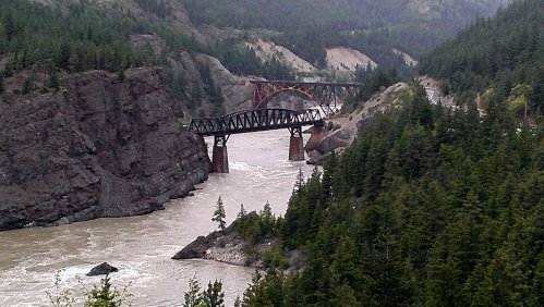
The night before, Tim and I decide to push a little further than our original plan with this day?s drive, so we end up in Cache Creek.  The drive took us along Canada Highway 1 which swings north and follows the Fraser River; which is a beautiful drive.  Tim loves it because the Canadian National Railroad is on one side of the highway; while the Canadian Pacific is across the river and in sight.  We are reminded of the last time we were in BC and how we stayed at a campground with both railroads situated just like this.  As we are ?whipping? by, we saw that old campground which is now abandoned and full of weeds.  When we stayed there the first time we had to turn the A/C in the motorhome just to be able to sleep.  With big semi-trucks and their exhaust brakes chattering down highway 1, and both railroads on either side, it was loud.
The sun peeks in and out of the clouds; the terrain is more dry and barren.  This area is heavily used as farming.  The dirt is pitch black and looks very rich.  This part of BC is called ?The Arizona Stretch? because of its climate.  It gets far less rain, has less timber and more rock.  However, I?m sure Arizona is much warmer.  We were hoping to stay at an old restored roadhouse where there was an RV park on sight; but we never found it.  We saw the sign, but no direction and not a clue as to where we should go.  I have a backup campsite which is easy to find and on the way.  It?s raining when we pull in; but the next morning we both are very excited to see the sun.  Not much to do here, we take off for Williams Lake.  We are trying not to just?drive?drive?drive, so the miles we are putting on are under 200 per day.  This stretch of the road is called The Caribou Highway and is following the old gold rush trails.  They have road houses spaced along the highway that used to provide food, shelter and equipment to the gold miners going up and down for gold mining.  As we were driving we would see 100 mile house, then 120 mile house etc.  All of this area up to Prince George is heavy gold mining.
Williams Lake is much bigger than we expected, but doesn?t seem to have very many campgrounds.  Our first thought was to stay for free at the Indian Casino; but that didn?t work out.  I was driving and we needed to pull over to find a suitable place so that we could make some decisions and by chance pulled in at the Stampede Campground, with a horse show going on no less.  I was in horse manure heaven?.listening to the whinnies, watching the cowboys and cowgirls ride their horses.  The campground was tight and very narrow, but manageable for an overnight. 
It was Tim?s birthday, so I took him out for dinner; but that was only to lift his spirits as well as to celebrate.  Earlier in the day we were going to do some sightseeing and check out the visitor?s center.  I had parked our little tow car between the motor home and a cute little rustic fence.  We both forgot about the fence and Tim clipped the front right bumper and pulled loose a fitting for the window washer bottle.  At first I thought he had ruptured the radiator and was relieved it was only the window washer.  But I?ll tell ya, these little foreign cars are like Legos pieces, they snap back together like a charm.  Tim took a hold of the bumper pushed it back into place snap?snap?.and we looked like nothing ever happened.  We did end up with a section that wouldn?t tighten up, so the campground host gave us a bungee cord, which we slipped in the right place, tucked it under the ?bra? of the front of the car and voila` we are stylin?.  I felt right at home, being a redneck from Alabama that looked like a pretty good fix to me. 
This trip has been about ?adventures? and new things to deal with.  Friday night was a new adventure.  During the middle of the night I hear this horrible sound and lots water hitting my side of the motor home.  I came out of a dead sleep thinking we were in a flood zone and were going to be washed away.  It was a high powered sprinkler that had nearly a 20 foot span and would rotate 180 degrees to cover the lawn.  We were really close to the sprinkler head so the force was pretty strong against the side of the coach.  I was prepared to run out in my pjs, grab the sprinkler head and change it?s rotation pattern.  Tim in his ever so clear engineering mind says:  ?I?ll just go put a rag on it??..I respond with: ?A rag on it, really??  Well, he put a rag on it and it kept it from spraying.  Adventure averted.
Saturday dawned beautiful and sunny.  We were over our yucky feelings from the fender incident.  Hooked up, headed down the road and within a mile, the tire pressure sensor went off for the tow car right rear.  Well, at least we are in a town where we can get a new tire.  I jump out to see how bad the flat is and there is no flat tire; it?s a good tire?no problems.  The problem is the sensor, we remove the sensor, throw it in the drawer and continue on down the road; heading for Prince George.
The terrain begins to change with more rolling hills, denser forest, shorter trees and less and less population.  We notice more pickup trucks; rugged pickup trucks with big grills on the front?..a real man?s truck. 
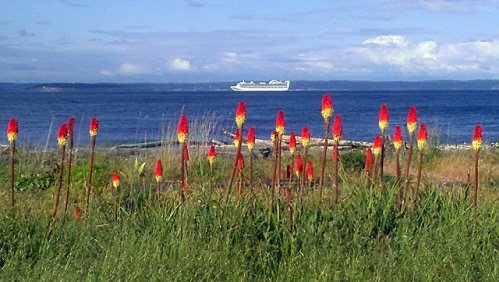
Since we had not filled up with fuel since Bellingham, WA we started keeping our eyes open for fuel stations.  Canada has a lot of commercial stations; but the further we go north the less public stations we are seeing.  We have plenty of fuel to get to Prince George, but we don?t like to it get too low.  About an hour south of Prince George we also begin to see road signs warning of moose and by golly right in the ditch both Tim and I see a female.  She is big?really big.  Then not a minute or two later we both see a deer.  Now deer are not an unusual sight for us, they graze right near our house.  But then only a minute later I see a black bear also down in the ditch but on my side so Tim missed seeing it.  We think this is an omen for good wildlife viewing; a moose, a deer and a bear all within 5 minutes.  This will be good trip.
We are now set up at Southland RV Park in south Prince George with 5 TV channels and wifi.  We plan to stay here a few days, do some sightseeing, grocery shopping and soaking up the sunshine.
 

Attachments

  • railroadBridges.jpg
    railroadBridges.jpg
    136.9 KB · Views: 39
We are in Dawson Creek waiting for the roads to open up. What is the route you are taking into Alaska? We read and heard there were evacuations due to flooding in Prince George. According to the provincial web sites:

- Campbell Highway of closed due to washout
- Alaska Highway just west of Watson Lake past Teslin is closed due to washout

We have been checking the following web sites:

http://www.community.gov.yk.ca/2012flood_activity.html
http://www.drivebc.ca/
http://511.alaska.gov/alaska511/mappingcomponent
http://511yukon.ca/

Here is one of the more pertinent excerpts:

Highway updates

FOR TRAVELLERS: If you are south of Watson Lake travelling north, do not proceed. The road is closed and there are is no accommodation available in Watson Lake. The road will be closed for several days.

Northbound from Rancheria ? (Alaska Highway to Whitehorse) - CLOSED
The Alaska Highway south of Rancheria is expected to be closed for several days while equipment is being mobilized and bridge parts are being assembled and transported to the site today. As soon as water levels allow, crews will begin channelling Canyon Creek from four channels into one. Once this work is completed an engineering assessment can be completed and a temporary detour constructed. This process will take days.


Prince George has some rivers swelling over the banks and a small number of residents being evacuated from homes along the shoreline.  Nothing major here that we can see; but we'll check it out further, just got here late yesterday. 

Our plans were from here to go to Prince Rupert, then up the Cassiar Highway (37) to Watson Lake, then west toward Whitehorse.  Thanks for all the links, we'll keep an eye on things.  Our original plan was not to cross into Alaska until close to July 1,  We decided this morning to continue on with going to Prince Rupert, hanging around on the Yellowstone Highway and even to go Stewart/Hyder checking the road conditions at that point, keeping our fingers crossed that the roads will open up. 

We had already decided we needed to start checking road conditions! 

Marsha~

 
I would image that would work. They should have it sorted out by then. The Yukon web site said that they were working on a single lane pioneer road (whatever that is). It should be complete in 24 hours. They were going to start a two lane detour road on Monday and it would take at least two days to complete.

We're hoping to get out of here on Tuesday or Wednesday.
 
We are still here in Prince George and plan to load up on groceries, keep checking the road conditions and head down the Yellowstone Highway towards Prince Rupert tomorrow.  I am reading on the road condition websites that the stretch between Haines Juction and Destruction Bay is passable.  Let me know if anyone knows any differently.

Tomorrow we will stay in Vanderhoof, leaving the coach there and taking the little car up to Ft. James, a fur trading re-enactment historical area.  I have reread Linda Stock's description of Ft James and am thinking it would be best to just do that as a day trip.  For those coming behind us toward Prince George on Highway 97, we are hearing that the side trip to Historic Barkerville is worth it.  We have been "hem-hawing" about taking the coach back near Hixon and then seeing Barkerville, but it's real hard to retrace our steps.  ::)  It's a 2 hour drive from Prince George.

At the Visitor Center yesterday, they assured us that the Cassiar is in great condition (their words) except for a 6 kilometer stretch.  Our weather here today is in the high 60s and with clouds/sunny at times.

For those interested, you can scroll either backward or forward depending on how you are viewing this tread to see photos I have attached on the Port Townsend/Seattle leg.

Marsha~
 
Roy,

I'll keep checking the websites, there is nothing on it about the closure at the moment; but that could change.  We had a drenching downpour for about half and hour late this afternoon. 

Marsha~
 
Back
Top Bottom