Directions to RV park

The friendliest place on the web for anyone with an RV or an interest in RVing!
If you have answers, please help by responding to the unanswered posts.

Ray-IN

Well-known member
Joined
Mar 16, 2014
Posts
3,762
Location
North America-somewhere
When their website states "do not follow your GPS", believe it. I once got within sight of an RV park but the bridge over a creek had a 3-ton weight limit.
I called the park and was told to ignore my GPS and follow the directions on their website, then she told me how to get back to the main highway, and the directions from there to the park. Thing is; I remembered reading that and immediately forgot. Old age can be a bummer.
 
So true. Google Maps will show roads that do not exist, or depict driveways (such as mine) or in my neighborhood's case, an aircraft taxiway, as a road.

I've seen this a number of times on campground sites, "follow the directions, not the GPS."

Here is an example from the Spearfish City Campground website, in South Dakota..................

Directions

Do not follow GPS directions. That route is closed and there is no turn around. Take exit 12 off Interstate 90. Go west, take left at second stop light on Canyon Street. Proceed to campground.

If you want to use GPS Use 423 Hatchery Circle, Spearfish - This will take you to the Fish Hatchery, we are just across the bridge.


Charles
 
In Branson one time we followed the GPS and wound up going through downtown in a 45' Beaver. Not fun, and at one corner had to have some traffic back up for me, since I couldn't back with the toad. Got to the campground and they gave a better way. Turns out the website said don't follow the GPS but I'd somehow missed that.
 
In Branson one time we followed the GPS and wound up going through downtown in a 45' Beaver. Not fun, and at one corner had to have some traffic back up for me, since I couldn't back with the toad. Got to the campground and they gave a better way. Turns out the website said don't follow the GPS but I'd somehow missed that.
Old downtown; man, that was difficult driving in my, at the time Chevy, LB, CC, dually. I remember the narrow streets with diagonal parking on both sides.
 
We worked two summers in a campground in Moses Lake, WA, that was plagued with that problem. Garmin insisted that westbound visitors take the wrong interstate exit and it went downhill from there. Eastbound travelers got the correct directions. My late wife (who is "directionally challenged" herself) worked in the office and had the chore of directing irate visitors to the park when they called. We actually went out on test drives to see where navigation went wrong and created recovery instructions to keep by the office phone.
 
At a CG I spent a couple of years at, the GPS took people in a farmer's driveway, through his back field, across a one-lane early-1800s covered bridge, down a jeep trail to stop at a creek bank across from the CG. Of course no one actually made it across the field. I did managed to get Garmin to correct their map.
 
Last I knew Garmin (and some others) bought their map data from Navteq, which is a business unit of Nokia. Navteq assembles it from a bunch of sources, including state & local plat maps, Geodetic Survey maps, federal highway system maps, etc.

Google builds their own visual maps but still utilize government sources to get the raw data, e.g. streets & road names/routes.
 
Not just campgrounds, but if you are driving around Baton Rouge, Louisiana, DO NOT FOLLOW your GPS. ...... Follow the signs..... Don't ask how I know. To much dang road construction going on!

Actually, the GPS is a good foundation to lay out a route. But double checking that agains a paper map is always good cautionary advise. Then when actually driving .... follow the signs and forget the GPS! Again.... it's basically a "dream world" reality .... but only in pipe dreams!
 
One park we like in Cooperstown, NY cautions against using GPS since it takes you on a road with a steep hill and sharp turns. Based on the preferred approach which has a steep hill and sharp turns, I'd hate to see the other road! We'll be there this summer again - maybe I'll take a side trip to check it out once we're unhooked and settled in. :cool:
 
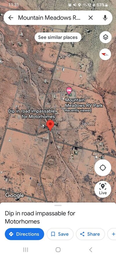
We stayed in a Passport America RV Park in Tularosa which had details telling you the route. Might have been me sending the updated info but Google knows about it now... will still take you that way in the directions though.

Screenshot_20240315_113150_Maps.jpg
 
So true. Google Maps will show roads that do not exist, or depict driveways (such as mine) or in my neighborhood's case, an aircraft taxiway, as a road.

I've seen this a number of times on campground sites, "follow the directions, not the GPS."
...

Charles
Or not show paved roads that have been there for over 100 years, or a 4wd goat track or hiking trail as a road.

I followed a google map suggested detour around a blocked highway once, and ended up in a farmer's barnyard.
 
Our first leg of our just completed two-month Southern states trip started in Huntsville, AL to visit the Rocket and Space Museum. We stayed at Monte Sano State Park. Luckily as we were about 15 miles out my wife checked the website for the park where she noticed a warning Do Not Follow GPS Directions to The Campground. It went on to state the road was impassable to large RV's with no place to turn around.

The next day we headed off to the museum using Google Maps. It took us out of the campground/park along the route that our Garmin was directing us to take into the campground. Whew to say the least! I thought that's why we have the Garmin, to avoid circumstances that "it" could've put us in.

Overall on our journey, there were several more instances where the Garmin failed us miserably, but my wife monitors where we are and is an excellent co-pilot when the directions seem suspect at best.
 
So true. Google Maps will show roads that do not exist, or depict driveways (such as mine) or in my neighborhood's case, an aircraft taxiway, as a road.

I've seen this a number of times on campground sites, "follow the directions, not the GPS."

Here is an example from the Spearfish City Campground website, in South Dakota..................

Directions

Do not follow GPS directions. That route is closed and there is no turn around. Take exit 12 off Interstate 90. Go west, take left at second stop light on Canyon Street. Proceed to campground.

If you want to use GPS Use 423 Hatchery Circle, Spearfish - This will take you to the Fish Hatchery, we are just across the bridge.


Charles
Google has led me seriously astray many times. I'm hoping RVLife GPS will be much better.
 
So true. Google Maps will show roads that do not exist, or depict driveways (such as mine) or in my neighborhood's case, an aircraft taxiway, as a road.

I've seen this a number of times on campground sites, "follow the directions, not the GPS."

Here is an example from the Spearfish City Campground website, in South Dakota..................

Directions

Do not follow GPS directions. That route is closed and there is no turn around. Take exit 12 off Interstate 90. Go west, take left at second stop light on Canyon Street. Proceed to campground.

If you want to use GPS Use 423 Hatchery Circle, Spearfish - This will take you to the Fish Hatchery, we are just across the bridge.


Charles
I've given up on Google maps since they redesigned their map display and now use Bing maps (maps.bing.com) or something like the RV Life trip planner on my PC.. Google Maps's web interface now shows all roads as single blue lines with single color route numbers, no differentiation between country roads and divided highways or Interstates. And they'll often drop entire towns if displaying the name conflicts with the road graphics. Look up Ely, NV and zoom out for one example. It will show the much smaller nearby town of Ruth but Ely itself disappears.
 
I've given up on Google maps since they redesigned their map display and now use Bing maps (maps.bing.com) or something like the RV Life trip planner on my PC..
I can see why the features that you mention are important to you. But:

Google Maps does not use Bing Maps, and they use different data sources. Google Maps uses data from its own street view cameras, MAPIT, and Tele Atlas, while Bing Maps uses satellite imagery, aer, and is partially powered by HERE
 

Latest posts

Forum statistics

Threads
131,990
Posts
1,388,722
Members
137,736
Latest member
Savysoaker
Back
Top Bottom