Looking for route tips/advice, first cross-country drive.

The friendliest place on the web for anyone with an RV or an interest in RVing!
If you have answers, please help by responding to the unanswered posts.

chaostactics

Well-known member
Joined
Jul 8, 2022
Posts
223
Location
Maryland
I'm planning on leaving the first week or two in Feb. I'm trying to hit as many national parks as I can. I'm towing a GD 2150RB. I will have a 3000 Ah with solar charging, the truck has a 7.2 KW power station built in and I will also be carrying a gas/propane genset.
26', GVW 6695 maybe less. RV is a 4-season unit, with a heated and insulated underbelly.
TV is a 2022 F150 Powerboost with 12.5k lbs towing capacity.
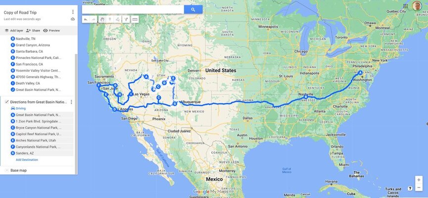
I can the northern route either first or second, makes no difference to me. Planning on making the drive over a month and a half to two months. Staying in a mix of campgrounds, legal retail lots, truck/rest stops, harvest hosts, boondockers welcome. Copy of RV trip map.jpg
 
Hi,

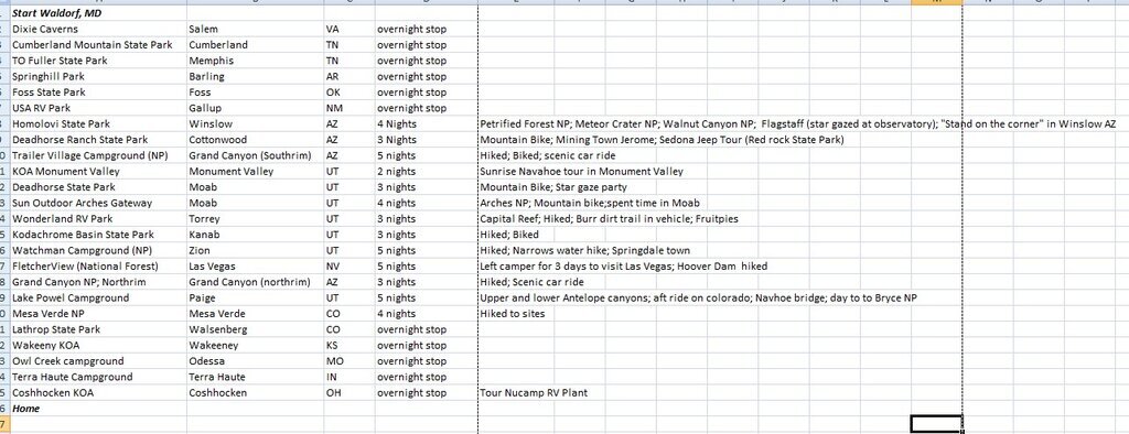
We did a 8 week trip from MD last year. We took the southern route out and the northern route back. Attached are the campgrounds we stayed at. Might provide some ideas. We had a blast...safe travels.

GrandCircle.jpg
 
Since you will be going through Grand Junction there's the Colorado National Monument. Best to unhitch in Fruita due to steep grades, tunnels, and narrow road along 500 foot cliffs.

The High Country overlooks such as in the Black Canyon National Park probably won't be accessible until late Spring. We're definitely going to be still snowbound higher up until then.
 
Last edited:
he High Country overlooks such as in the Black Canyon National Park probably won't be accessible until late Spring. We're definitely going to be still snowbound higher up until then.
Yep. And Trail Ridge Road (U.S. 34 through Rocky Mountain National Park) normally doesn't open until Memorial Day (and sometimes later), plus there are a number of other high areas the same way. Interstates are generally open year 'round, even through the high country, but there are still occasional closures through the year, due to rock slides, traffic messes, avalanches, etc., even flooding or major fires on rare occasion.
 
Yep. And Trail Ridge Road (U.S. 34 through Rocky Mountain National Park) normally doesn't open until Memorial Day (and sometimes later), plus there are a number of other high areas the same way. Interstates are generally open year 'round, even through the high country, but there are still occasional closures through the year, due to rock slides, traffic messes, avalanches, etc., even flooding or major fires on rare occasion.
Not going to the Rockies at this time, but good to know. In CO I'm doing black canyon and great sand dunes
 
Since you will be going through Grand Junction there's the Colorado National Monument. Best to unhitch in Fruita due to steep grades, tunnels, and narrow road along 500 foot cliffs.

The High Country overlooks such as in the Black Canyon National Park probably won't be accessible until late Spring. We're definitely going to be still snowbound higher up until then.
Super bummer black canyon was on my list. I'm not above dropping the RV at a site and then just taking the truck to a park. Though an impassible road is an impassible road. I sure won't be there in late spring.

Some of the stops are to truly stop and enjoy the park's hike, backpack, mountain bike, whatever, and some are just to say been there.
I found places like Hot Springs in AK to be disappointing and a 90 min stop max. Places like Saguro, Whitesands, Redwood, and some. only required a few hours when I visited.

I expect a couple of the parks along my route to be the same. Gateway Arch, for instance, others I will probably spend a couple of days at.
 
Not going to the Rockies at this time, but good to know. In CO I'm doing black canyon and great sand dunes
Believe it or not, you can't get to the Sand Dunes without going through a piece of the Rockies, though it's southern Colorado and somewhat lower elevations than going I-70. Nor do I know how you'd get to the Black Canyon of the Gunnison without going through the Rockies.

In fact, if you go through Colorado to any state except Wyoming (staying east of the Rockies), or even appreciably further west than I-25 you cannot avoid some piece of the Rocky Mountains, since they literally run from El Paso, TX (actually from Mexico) through Montana into Canada. Granted that some areas are easier travel than others, though.
 
You can drive to the South Rim Visitor Center which overlooks the Black Canyon of the Gunnison. Elevation approximately 8,000 feet. The trails to the overlooks though might be closed due to hazardous and icy conditions. From my north side of the Gunnison River via Crawford it's all closed. Everything beyond the South Rim Visitor Center is closed.

We live within the Rockies on the north side of the Grand Mesa. Our 6,000 feet elevation has snow. 8,000 feet has lots of snow and at 11,000 feet where our highway summits it's buried in snow, but plowed. The Black Canyon National Park is in the Rockies. Can't get across Colorado without being in Rockies. There's no route that bypasses them in Colorado.

This is how much snow near where we live on the Western Slope this season...24 feet and more to come. Just don't want for you to be disappointed in February for not being able to get far from your truck without skis, snowmobile, or snowshoeing.


October 2022: 30″
November 2022: 29″
December 2022: 82”
January 2023: 143″

2022-23 Season Total: 284”
Snow Total in the last 24 hours: 15″ as of 1/19/2023

Current Black Canyon status...


Road Closures

The South Rim Road beyond the Visitor Center is closed for the season.

The East Portal and North Rim Roads are closed for the season.

South Rim
The South Rim Drive is usually open to vehicles from late-April to mid-November. In winter, the South Rim Road is open to Gunnison Point at the visitor center. The remainder of the road is closed to vehicles, but open to cross country skiing and snowshoeing when conditions permit.

North Rim
North Rim Road and ranger station are closed to vehicles in winter. The road typically closes late November and reopens mid to late April.

East Portal
East Portal Road is closed in winter. The road typically closes mid-November and reopens mid to late April.
 
Last edited:
My two thoughts this is expect to see a lot of snow and ice, and to take a more southern route west first, watch the 7-9 day weather forecast in the days leading up to your departure and be prepared to make adjustments, as even central and northern Texas can see show and ice in mid February many years. Also keep in mind that even crossing I-40 in New Mexico the interstate can close due to snow and ice at elevations. (Albuquerque is at an elevation over 5300 feet, which is higher than Denver, and I-40 reaches over 7,200 ft near Gallup). Even I-10 reaches over 5,000 feet while crossing AZ.
 
I've only seen I-40 close here in ABQ a handful of times in 30+ years but especially points east has it's share of closures too, so there might be a few somewhere every winter. I would say the Flagstaff section has more chance of snow and closures but I took I-40 to quartzsite a few years ago, so I wouldn't avoid the route preemptively. Just keep an eye on the weather and have a bug out strategy in the event you're stuck for a day or two. The hotels fill up fast in the small towns but in a 4 season camper you could probably hunker down most anywhere. Thing about winter weather in NM is it never sticks around long. It blows through, they plow the road and it's back to business.

Do the attractions have to be outdoor/scenic or do cultural/historic ones count? I would say there aren't many multi-day class destinations here but enough to offer a day's worth at a given location. You could spend a day doing the enchanted circle, Jemez scenic byway would be another day, maybe a day each knocking around Santa Fe and ABQ. There's the VLA to the south and maybe you'd detour I-40 that way to go through the valley of fire, and pick I-40 back up close to TX after you visit the billy the kid museum.

Mark B.
Albuquerque, NM
 
I would strongly suggest you take the southern route first, but even then, you are going to experience a lot of ice and snow, especially in Colorado and even Utah. You might want to go through and check the typical weather for each of your stops using this tool: Climate United States - Normals and averages

Is there any way you can postpone leaving for this trip until late March or even April? You list things like hiking, but there will still be heavy snow in a lot of the places you list, so not sure you want to hike in snow.
 
@JudyJB @Western Slope @Mark_K5LXP @Isaac-1 @Larry N. @Yoshi
Thank you all so much for your input and advice.

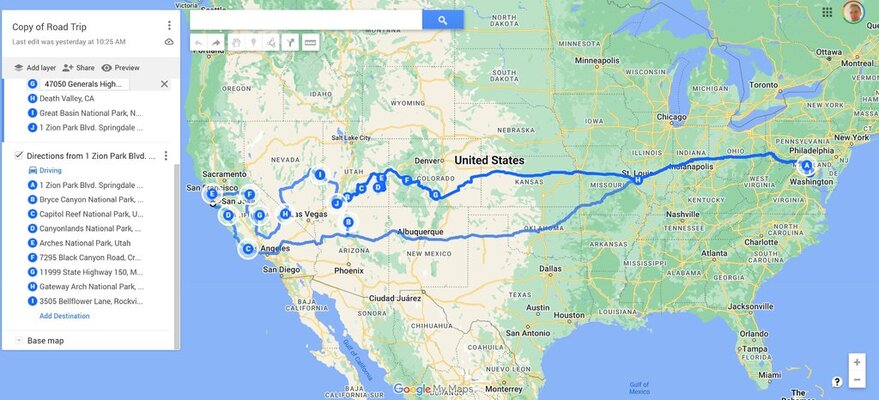
Due to feedback here and other forms, I have revised my route as attached. Primarily to keep on or south of I-40 for most of the drive and to steer clear of Colorado.

NOTES:
*This is the only window I will have for a trip of this magnitude for probably 10-20 years. So its now or never for me. (I am nowhere near retirement age, I'm 36 and myself and my SO have very demanding jobs that would only allow 2 weeks of vacation max)

*Some are suggesting I travel on I-10 or I-20. I have done each of those routes (sans RV) multiple times including I-10 and I-20 since New Year's 2023.

*I have also already hit every national park south of this route.

*In some parks, I may spend a day or two exploring back packing, snow shoeing, biking etc. Some I may only do a few hour jaunts in.

*The lack of intermittent stops on the map don't indicate I'm trying to do it in a single day run, its just there to indicate the over all run. e.x. the run from MD to Grand Canyon.

Any new thoughts? You all have been SO helpful!!
 
I did a few cross country trips like this on my scooter years ago. And you're right, take it while you can because at least in my case that opportunity hasn't happened again since, and may never.

Given the distance the number of potential stops is imponderable depending on your interests, schedule and often just luck encountering stuff. I tend to bookmark "must" stops along the route then go with the idea that along the way I'll see or become aware of other attractions/events. It usually works out that I end up with more stuff I want to see than I have time, so the journey is full.

Mark B.
Albuquerque, NM
 
(Albuquerque is at an elevation over 5300 feet, which is higher than Denver, and I-40 reaches over 7,200 ft near Gallup).
Albuquerque ranges from about 5,000 ft at the Rio Grande River to 5,900 or so on the east side near the Sandias, and near 6,000 on the west mesa. And Tijeras Canyon (coming on I-40 from the east) is also over 7,000.
 
Albuquerque ranges from about 5,000 ft at the Rio Grande River to 5,900 or so on the east side near the Sandias, and near 6,000 on the west mesa. And Tijeras Canyon (coming on I-40 from the east) is also over 7,000.

This seems important but I'm not sure what I should do/consider with this information.
 
You are so focused on everything West of the Mississippi River, don't loose sight of opportunities for things to see and do East of the Mississippi too, while on your way "West."
 
You are so focused on everything West of the Mississippi River, don't loose sight of opportunities for things to see and do East of the Mississippi too, while on your way "West."

Right now I'm only pursuing national parks due to limited time. I've also done pretty extensive travel on this side of the Mississippi. Once I get back to home base in MD I'll spend more time RVing around east coast and some inland.
 
The good news is that your youth means that this will not be your last trip out west. And your route looks a bit better. A couple of suggestions--have you been to White Sands National Monument and Alamogordo? Nice "barefoot" hiking in the soft sands at White Sands. If you go there, I highly recommend Oliver Lee State Park. What about Tucson and the Pima Air Museum and "Boneyard" where they take planes apart. Also excellent Arizona-Sonora Desert Museum.
 
Back
Top Bottom