Confederation Bridge & PEI

The friendliest place on the web for anyone with an RV or an interest in RVing!
If you have answers, please help by responding to the unanswered posts.

Houseofarticcats

Active member
Joined
Jun 29, 2006
Posts
33
Location
NH
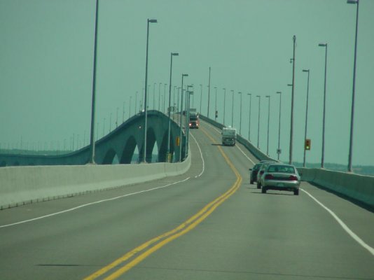
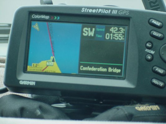
Not to change the subject.. But what did you think of the Confederation Bridge ?  When we went across  it we were all excited... We stopped at the end and went to the shops and walked over to the display they have of the bridge section and all the bricks with all the names on them.. Just incredible.... We did get a few pictures while we were crossing....(well my wife did.. I was driving and tiring to watch the road..heheheheh )
 
Hi Houseofarticcats,

What did we think of the Confederation Bridge ?

Well, erm, well - it was just a bridge. A long bridge, but just a bridge.

Maybe we will appreciate it a little more when we have to pay the $50cdn (yes $50cdn !!) toll charge on leaving the island? :'( :'(.

We didn't stop at the beautiful looking "village" when we crossed the bridge and are planning to spend an hour there on our return to the mainland.

Paul
 
Paul

We agree with you, it's just a bridge. And one they shut down for a long time when a wide load has to cross. We sat for about an hour waiting for one coming from the mainland to the island.

If you are planning to spend any time in the Charlottetown area, right across the river is the Southport RV Park. All the spaces face the river with a great view of downtown Charlottetown. We found it very convenient to tour just about the whole eastern half of the island from there.
 
Paul..
I didn't even think about the cost at the time... I do know it was cheaper then the ferry...I just thought it was cool to drive it....  ;D and yes it is long.. very long..heheheheh My wife got me the video of it...I was cool to watch how they built it.. I have relatives on PEI... Hunter River...
Hope you enjoy the island....
Gus..
 
Houseofarticcats said:
Paul..
I didn't even think about the cost at the time... I do know it was cheaper then the ferry...I just thought it was cool to drive it....  ;D and yes it is long.. very long..heheheheh My wife got me the video of it...I was cool to watch how they built it.. I have relatives on PEI... Hunter River...

Gus

Depends on which way you go. We took the ferry over to PEI and the bridge back. No payment on the ferry, just to cross the bridge. If you take the ferry back, there is a small surcharge, not to bad IIRC.
 
No it is not just a bridge.  It's a very long crossing over treacherous water with tides and currents and sub freezing winter temperatures carrying huge accumulations of ice.  A great deal of new technology was developed in the design of the Confederation Bridge which is now being applied worldwide to construct longer crossings in deeper and colder water.
 
If I remember right.  We took the bridge over and got off PEI via a ferry.  That combination (in that order) resulted in no bridge fee.  As for the bridge, the only thing of note was the S&T 2003(?) had it's main land end wrong by 3 miles.  No big deal since there was only a costal road leading up to it....couldn't get lost and we say it long before we got to it.
 
Hi Len,

Strange that S&T would be off by that amount. The attached photos show where our StreetPilot had us.
 

Attachments

  • Confederation bridge.jpg
    Confederation bridge.jpg
    41.2 KB · Views: 24
  • confed_br.jpg
    confed_br.jpg
    44.1 KB · Views: 25
Good Pics!!!

Yes, it was funny.  I watched it as we crossed.  The main land end we drove over watet but as we got closer to PEI the S&T circle converged with the PEI end of the bridge and we were driving on dry land and roads again!!!.  The program had several road location errors in New Brunswick.  The program had the roads on PEI all in right locations.  Same with Nova Scotia.  Just New Brunswick put their roads in the wrong locations.  Must not have used S&T to lay them out.
 
When my GPS starts off off-route and gradually corrests it is usually receiving only three sats and as it picks up more siignals it becomes more accurate.
 
Mine to, but in this case 2003 S&T had the roads and south end of bridge in wrong location.  It didn't cause us any problems since we also carry paper maps.  We have also seen errors with 2005 S&T but not as bad and usually with new road construction.  We have driven parallell to new roads but 1/4 to 1/2 mile off the map indicated road.  Assume info was loaded prior to road completion.  The vast majority of S&T information though is very good.
 
Back
Top Bottom