Senic Routes through the south.

The friendliest place on the web for anyone with an RV or an interest in RVing!
If you have answers, please help by responding to the unanswered posts.

Len and Jo

Well-known member
Joined
Apr 25, 2005
Posts
1,442
We traveled from Gettysburg to the Smokey Mountains via the Sky Line Drive and the Blue Ridge Trail a few years ago.  Several people along the way said there is a simular drive/trail going from east-west in the Alabama, Mississippi, and Arkansas area.  Does anyone know of such a simular drive and can supply details on it???  Seems like it would be a good round-about way to get back to Michigan after the Fall Rally ::) :p.
 
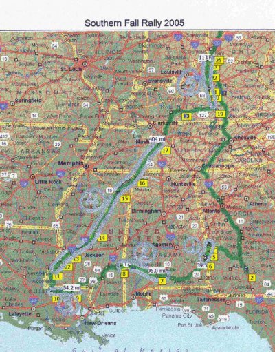
Well this is the "Scenic Hwy" trip so far.......it does take use accross Alabama, Mississippi, Louisiana, and up through Tennessee and Kentucky.? Got the Scenic Highways from a Road Atlas.? Has anyone taken some of these smaller roads?? :eek:


MILEAGE
0 Depart Berkley, MI
I-75 SOUTH
911 At Tifton, Ga. FOR SOUTHEASTERN FALL RALLY
1051 Phenix City, Al.
SCENIC HWY (37MILES - LOCAL 12) ;D
1088 At Eufaula, Al.
1240 At Belleville, Al.
SCENIC HWY (104 MILES - STATE 84) ;D
1344 At Waynesboro, Miss.
1495 At Fluker, La.
SCENIC HWY (57 MILES - LOCAL 10) ;D
1552 At St. Francisville, La.
1612 At Natchez, Miss.
NATCHEZ TRACE PKWY - SCENIC HWY (446 MILES) ::)
2058 At Leipers Fork, Tenn.
Louie B Nunn Cumberland Pky ???
2283 At Ringgold, Tenn.
SCENIC HWY PARALLELS I-75 (44 MILES - LOCAL 150) ;D
2327 At Danville, Tenn.
SCENIC HWY PARALLELS I-75 (125 MILES - LOCAL 127/42) ;D
2413 At Glencoe, Kentucky
I-75 NORTH
2723 Arrive Berkley, MI 48072
 
The attached jpg file picture is scanned from S&T 2005.  The five scenic routes we are planning on taking are outlined in silver.  Would have up-loaded original S&T file but that is not a allowed file type.
 

Attachments

  • Rally scenic route home.jpg
    Rally scenic route home.jpg
    230.2 KB · Views: 37
Len

If it's a route that you create and not one of S&T's copyright files, let me know the file type (.ext) and I can add it to the allowed file types. I see a real benefit in folks being able to share routes that they've created &/or travelled.
 
Tom,

The Streets and Trips file extension is:  xxxxxxx.est
Yes, it appears that lots of use use it.
 
OK thanks Len. I went ahead and added .est files to the allowable attachments.
 
You may want to add .saf, .anr. and .an1 extensions also.  Those are the extensions for DeLorme map files, routes, and draw files.  None contain proprietary information.
 
Fast work Tom!!

Attached is our proposed trip to and home from the Fall Southeastern Rally with "scenic highways" on the way home.  The scenic areas are marked with yellow.
 

Attachments

  • Southern Fall Rally 2005.est
    195.5 KB · Views: 35
Back
Top Bottom