You are using an out of date browser. It may not display this or other websites correctly.
You should upgrade or use an alternative browser.
You should upgrade or use an alternative browser.
Streets & Trips 2006
- Thread starter BruceinFL
- Start date
The friendliest place on the web for anyone with an RV or an interest in RVing!
If you have answers, please help by responding to the unanswered posts.
If you have answers, please help by responding to the unanswered posts.
WOW - just upgraded to Streets & Trips 2006 today.
Just one of the benefits is to have it linked to a map in MSN Virtual Earth
See http://local.live.com/default.aspx?v=2&cp=47.783029~-122.216206&style=o&lvl=2&scene=3690308 for a fantastic pic of our current campground.
We got our software for just $24.27 at Sams Club !!
Whilst Im talking of Sams Club - 24 exp film developed 6x4 AND a CD copy of pics for $6.60 - all in an hour, great !!
Paul
I purchased s&t 2006 Jan 4Th 06. I have a 5 year old HP laptop, and initially the GPS wouldn't work. The customer support got that right quickly, but then the voice wouldn't work. They said they'd get back to me on that, but never did. Other than that, it works pretty good. It did insist on directing me back in the wrong direction when I got off route in Toronto though.
Tom
Administrator
- Joined
- Jan 13, 2005
- Posts
- 51,906
Jake,
Streets & Trips has a GPS interface. It also has an option to scan all your ports looking for a connected GPS device.
FWIW most, but not all, GPS devices output data in what is known as NMEA format which can be read by software such as S&T, DeLorme's Street Atlas and others.
Streets & Trips has a GPS interface. It also has an option to scan all your ports looking for a connected GPS device.
FWIW most, but not all, GPS devices output data in what is known as NMEA format which can be read by software such as S&T, DeLorme's Street Atlas and others.
The S&T I bought came with the gps locator for $119.99 plus tax. The S&T provides a window with several choices to display your position moving on a map including direction and speed. You program your route ahead of time and it gives you directions and distance to the next turn.
Tom
Administrator
- Joined
- Jan 13, 2005
- Posts
- 51,906
King,
I forgot that S&T can be purchased both with and without a GPS receiver. I bought mine without and used my own receiver.
I forgot that S&T can be purchased both with and without a GPS receiver. I bought mine without and used my own receiver.
UK-RV said:Just one of the benefits is to have it linked to a map in MSN Virtual Earth
See http://local.live.com/default.aspx?v=2&cp=47.783029~-122.216206&style=o&lvl=2&scene=3690308 for a fantastic pic of our current campground.
Paul
How do you do the link? What are the steps?
Thanks,
Bob Zambenini
Well-known member
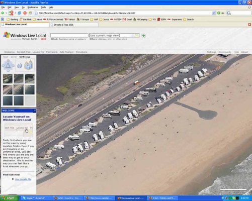
Maybe everyone is not familiar with this msn local.live.com so I am including a screen shot of the Bolsa Chica State Beach Campground in Southern California.
You don't need S&T to use this information. Just go to the www.local.live.com website.
I am going down to Temucula next week and I used it to review the campground campsites, entrance road, etc.
When you look at this attached screen shot, to the left you see a box with some small photos squares and above you have choices of road, Aeriel, or birds eye views. You start with road or Ariel (which is like google earth) and position yourself. Then if birds eye shots are available it will show and you can move around with oblique views. As you move North, East, South and West you get different shots and probably taken at different times. Like this one, some views are taken with the campground was under construction a few years back.
Its a beta system now and not a lot of areas have oblique birds eye views, but most of Southern California is covered. Its also cumbersome to work so have to be patient. If you want to practice, go to shots of Las Vegas and see some awesome shots of strip casinos.
I can be very helpful like in the case my trip. I am also going to Fallbrook and in the back gate of Camp Pendleton. I have done this once before and its a little tricky getting through the town and to the gate so I printed out a photo which I will have handy. Neither Delorme SA or S&T have this roads into this gate correct but the photo is actual and great!
I don't know how fast they will have more coverage of this birds eye views or how it will be fully integrated into Streets and Trips, if ever. Maybe when we have high speed internet while driving down the road! Then we would have a moving photo map with choice of multiple panning views.
Bob
Attachments
OMG - Never Again !!
We just tried the Streets & Trips 2006 for our navigation this morning.
We were booked into a Freightliner Service Centre 7 miles from the campground we are staying.
OK, I made a basic mistake to begin with in that I entered just the road name and not the property number as our destination.
S&T took us to within 2 miles of the road and told us to turn off, which we did.
We then drove down the stated road, only to find it is closed half way down (it looks like it has been barriered for some time), so we had to follow the road round and then take the RV down a 20% (!!) decline.
All the time this is happening, S&T simply draws a nice little blue line showing where you have been - unlike PROPER gps systems it doesn't try to reroute you back on track.
We then got back onto the main road we started on and were instructed to drive past the previous point we'd been told to turn.
When we got to the programmed street and turned right as stated, we entered a restricted zone and had to make a u-turn.
We then drove down the named street for at least 5 miles.
At this point, I thought it best to pull over and find the full address to enter into S&T.
The software took us down the road but failed to notice the road had been demolished in favour of the main Route 1 thru Vancouver, so again we had to just drive around not getting any help from S&T other than that little blue line showing you that you dont know where you are.
We finally got to the service center after driving for 80 minutes - the drive back to the CG tonight took us 12 minutes.
So, whilst I think S&T is GREAT for finding a CG and searching for surrounding things like restaurants, fuel stops etc - it is useless as a stand in for Sat Nav.
Paul
") :
:I find S&T to have an unfriendly user interface and nothing to approach the flexibility of DeLormes draw layers. I've given S&T a shot but I'm sticking with the DeLorme products. The DeLorme map file organization and the powerful draw layers keeps them well ahead of the other mapping programs.
All of the mapping programs suffer from the same problems in keeping the databases up to date. They all rely on other parties to supply their base data and often times areas will be several years behind actual road construction. None of the consumer mapping programs is perfect in that regard. Unfortunately, if you happen to frequent an area that is out of date, it's all too easy to judge a product on that one flaw.
All of the mapping programs suffer from the same problems in keeping the databases up to date. They all rely on other parties to supply their base data and often times areas will be several years behind actual road construction. None of the consumer mapping programs is perfect in that regard. Unfortunately, if you happen to frequent an area that is out of date, it's all too easy to judge a product on that one flaw.
Ron
Moderator Emeritus
But from another prospective IMHO the last friendly Delorme product was SA9. As far as I am concerned Delorme went down hill after SA9. IMHO while not perfect Streets and Trips far exceeds Delorme now. The Lowerance GPS like Tom has really looks nice and would be high on my list of possibilities if I were to purchase another GPS.
BlueRooster
New member
- Joined
- May 3, 2006
- Posts
- 1
We used this for the first time this weekend on our trip from Tallahassee, FL to the Kentucky Derby.? We routed our trip through Birmingham and Nashville to avoid the mountains and visit friends (free stopover in Nashville)..? I was fairly impressed with the interface as well as the guidance it provided.? The accuracy of the GPS was nice and the detail (where it was accurate - more on that in a bit) was incredible.
But....
I know this was the first time we had played with it and there are certainly more features that we didn't get to in this trip but I am a techie by profession so I feel like I got a pretty good grip of it, so here are the negatives----
1.? As stated above, thanks for telling me I am off course, but how about remapping a suggestion to get back??? We didn't need this feature but (being a man I can't ASK for directions - but if a computer tells me where to go....) I can see this as being necessary.? Thisseems like it is pretty standard....
2. As best I can tell it these maps are at least 3-4 years out of date (at least for Tallahassee).? I don't expect them to be able to keep up with all the new roads but our I have been in my house for two and a half years and our subdivision of approximately 1000 new houses and a golf course is not on the map...? Granted that is a subdivision, but the "new" divided four lane artery that was put in through the middle of town is not there either...? pretty glaring omission to me...
3.? The quickest and shortest routes interface was a little too complicated....? Again I am a techie so I figured it out, although I question some of the results, but a non-techie might not get it.
4.? I like the display of current speed on the GPS pane but it doesn't translate efficiently to the other screens...? And it would be nice if the system could tell the posted speed limit also. i.e? your speed / posted speed = 53/55
5.? In the guidance/directions it would be nice if it told you how far your total trip distance was as well as each leg ..... i.e. leg/total? 22.6/198.4
Again,? overall we liked the product but it does have more that it needs...? but then I am an information happy thirty-something that gets bored driving down the road listening to Buffett and redneck comedy.....
1. Street Atlas will optionally recalculate your route when you go off route.
2. That's a common problem with all mapping programs. Some areas will be several years behind while others will be up to date. There is no simple solution other than the extremely expensive mapping databases.
3. All of the mapping programs with routing capabilities have multiple options to let you tell it how to route for your driving habits. Some are easier to use than others, but all take some experimenting to use proficiently.
4. I doubt that the databases have posted speed limit information. Street Atlas does let you set the speeds for different road types.
5. Again, Street Atlas shows (optionally at your choice) the time and distance to finish as well as to the next route segment.
I too have used the MS Streets and Trips. I purchased new for 2006. IT came with the GPS receiver for about $80.00 from Best Buy (on sale). The mapping data base is up to date in most metro areas. Some one stated that it was not capable of re-routing if you go off route. If you have the GPS pane open, a button on the right of the screen ask, "re-route from current location", just press that button with the mouse and it will re-route you back to the next way-point. The only draw back I see so far, is the updated map's. MS will not update the previous version. You have to purchase the 2007 version. But the GPS receiver will work also.
Tom
Administrator
- Joined
- Jan 13, 2005
- Posts
- 51,906
Keep an eye open at Costco. I previously bought S&T there for free, or almost free, after rebate. The routing tools aren't as good as DeLorme, but it works. (I have DeLorme too).
BruceinFL said:I've got em all....S&T, SA, Copilot. I mainly use S&T for planning and Copilot for navigation. None of the software packages are perfect and none has more accurate maps than the other. I have found errors in all of them.
Bruce:
I agree, for me its S&T, SA, and Garmin's Mapsource software. I use S&T for almost all planning and the Garmin and S&T while driving.