You are using an out of date browser. It may not display this or other websites correctly.
You should upgrade or use an alternative browser.
You should upgrade or use an alternative browser.
How people get in trouble blamed on their GPS
- Thread starter Kirk
- Start date
The friendliest place on the web for anyone with an RV or an interest in RVing!
If you have answers, please help by responding to the unanswered posts.
If you have answers, please help by responding to the unanswered posts.
Mountain high
Guest
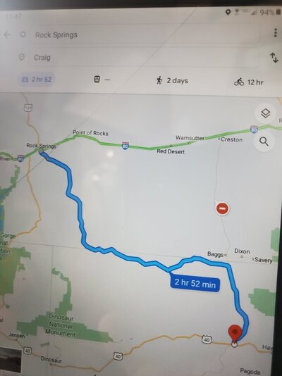
Wyoming I-80 was closed on Saturday due to winter conditions. GPS is still sending vehicles and trucks to the barren unmaintained in winter nothing dirt roads in the no man's land regions of Northwestern Colorado. Stupid people are going to die out there. There's around 50 vehicles and trucks stranded and abandoned out there this year.
Last edited:
DonTom
Well-known member
So what do the nonstupid people do in that unexpected situation? How would one know which GPS routes to avoid in an unfamiliar area?Stupid people are going to die out there.
I have seen many a road start out great and keep on getting rougher and rougher.
-Don- Reno, NV
Contributor
Well-known member
- Joined
- Jul 9, 2022
- Posts
- 1,423
Using the term GPS bundles a lot of different applications into one category. Apps that use up to date information on weather, traffic and road conditions in conjunction with GPS are very helpful. Using straight GPS is asking for trouble.
In my car, I have the latest North America Maps and there are still portions that are plain wrong. But GMaps is much better, but not perfect.
In my car, I have the latest North America Maps and there are still portions that are plain wrong. But GMaps is much better, but not perfect.
Mountain high
Guest
So what do the nonstupid people do in that unexpected situation? How would one know which GPS routes to avoid in an unfamiliar area?
I have seen many a road start out great and keep on getting rougher and rougher.
-Don- Reno, NV
And that's what the roads are going from Wyoming to Northwestern Colorado north to south. Except for Wyoming 789 to Colorado State Highway 13 through Baggs there are no other good routes. Laramie to Walden, but that's on the east side of Rabbit Ears Pass and Gore Pass. Right when you cross the border into Colorado the wide shoulders of Wyoming highways are gone.
UTTransplant
Well-known member
Non-stupid people driving big vehicles don’t blindly follow any recommended alternative route. They look it up on a trucker’s atlas and check it on satellite images before turning off. I can guarantee a road that turns to dirt isn’t an approved truck route! As for cars, people who leave the main roads must not be familiar with mountainous terrain. Lots of places just don’t have alternate paths, as Western Slope noted.
Yesterday used Waze to route me in a MoHo towing truck on dolly from I-20 in Ruston, La. to Jimmy Davis State Park about 30 mi. S. wound up on a 10 mi stretch of La. 146 barely wide enough for two cars to meet and no shoulder, nada, zero margin for error. You couldn’t have driven a needle up my a with a 5lb shop hammer. Next time I’ll check the map.
Mountain high
Guest
People should know where they're heading. South of the east-west I-80 in Wyoming Google Maps is attempting to reroute drivers towards the east-west US 40 and maybe further south to the east-west I-70. It's either barren high desert plains and/or mountainous country. There are only two paved north to south routes to get south through either Baggs, Wyoming on the west side of the Continental Divide or through Walden on the east side. Both towns populations are just 600 people each. Way far north of Maybell, Colorado which has a population of 36 is where Google Maps sends them. It's through some deserted dirt roads where no one lives. Maybell has Colorado's lowest record cold temperature of negative 61 Fahrenheit.
Alan_Hepburn
Well-known member
"Non-stupid" people would probably understand that if the interstate was shut down due to weather then secondary roads would probably also be shut down...it's only common sense that whoever is charged with keeping roads passable would prioritize major roads over secondary roads.So what do the nonstupid people do in that unexpected situation? How would one know which GPS routes to avoid in an unfamiliar area?
I have seen many a road start out great and keep on getting rougher and rougher.
-Don- Reno, NV
Didn't I see somewhere that Google had stopped that diversion when I80 blocked or was that a one time only deal?People should know where they're heading. South of the east-west I-80 in Wyoming Google Maps is attempting to reroute drivers towards the east-west US 40 and maybe further south to the east-west I-70. It's either barren high desert plains and/or mountainous country. There are only two paved north to south routes to get south through either Baggs, Wyoming on the west side of the Continental Divide or through Walden on the east side. Both towns populations are just 600 people each. Way far north of Maybell, Colorado which has a population of 36 is where Google Maps sends them. It's through some deserted dirt roads where no one lives. Maybell has Colorado's lowest record cold temperature of negative 61 Fahrenheit.
Mountain high
Guest
Didn't I see somewhere that Google had stopped that diversion when I80 blocked or was that a one time only deal?

No. I just typed in Rock Springs, Wyoming to Craig, Colorado. The only paved highway is I-80 to Wyoming 789 down through Colorado State Highway 13. Highway 789 is showing closed. It might not be, but the Google Map Artificial Intelligence looks for cellphone movement. Google Maps shown route is through County Road 4. It's a dirt road out in the boonies far away from any civilization. It goes through no civilization. I have to admit this area is entirely deserted on a good day and I've been to Irish Canyon in Colorado up near there, but not on Road 4 wherever that is. That's where they are finding people stranded.
A Traveler
Well-known member
- Joined
- Aug 25, 2014
- Posts
- 660
I would never - EVER - use Google maps to look for a route when driving the motor home. Google doesn’t know anything about your vehicle height and weight, so it will route you on roads suitable for cars, not 35,000 pound, 13-foot high buses.
Mountain high
Guest
Correction I have towed east on County Road 4 to CO Highway 13 near Baggs, Wyoming several years ago from where it first crosses the Little Snake River. Was heading north from Maybell, Colorado. I remember lots of heavy trailing dust until County Road 4. Turned into a narrow 2 lane rough asphalt road with no shoulder following along the river. Nothing special to look at out there. Just high desert sagebrush. No services of any type.
DonTom
Well-known member
Yep. What I would do is change plans. Perhaps go back the way I came, if possible and go somewhere else. I make sure my RV trips have plans that can change at any time, I try to avoid making reservations anywhere."Non-stupid" people would probably understand that if the interstate was shut down due to weather then secondary roads would probably also be shut down...it's only common sense that whoever is charged with keeping roads passable would prioritize major roads over secondary roads.
Or I will find a place to wait it out. I never have firm plans on any of my RV trips.
-Don- Reno, NV
Ray-IN
Well-known member
Actually that's where a CB radio enters the picture.So what do the nonstupid people do in that unexpected situation? How would one know which GPS routes to avoid in an unfamiliar area?
I have seen many a road start out great and keep on getting rougher and rougher.
-Don- Reno, NV
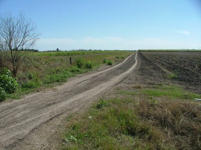
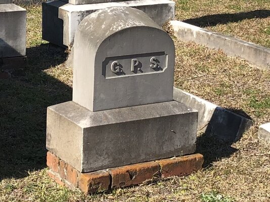
Years ago in Florida my GPS(set to my RV stats) told me to turn here:

LarsMac
Well-known member
I seldom ask Google for a route until I already have looked at the map and pretty much know where I am going. I use Google or Garmin as a reminder of where my turns are while I'm driving.
I will often tweak the map and add intermediate destinations to make sure it is taking me the way I want to go.
A lesson learned some years back, when we got an unscheduled tour of the Tennessee back woods.
I will often tweak the map and add intermediate destinations to make sure it is taking me the way I want to go.
A lesson learned some years back, when we got an unscheduled tour of the Tennessee back woods.

