Bentsen-Rio Grande Valley State Park

The friendliest place on the web for anyone with an RV or an interest in RVing!
If you have answers, please help by responding to the unanswered posts.

DonTom

Well-known member
Joined
Apr 21, 2005
Posts
13,417
Location
Auburn, CA or Reno, NV
It sure was nice to get out of my RV Prison after 3-days & night of nonstop rain. Now, only nice warm WX on the forecast, in fact, I have both my A/Cs on right now at almost 1800 hrs. Nice warm sunny day with only a couple of white clouds.

I did a short hike in the park today, well not that short as I hiked a few miles inside. As I expected, much of it was very muddy after three days and nights of mostly heavy nonstop rain.

It costs five bucks to enter for each day. A yellow band on everybody's wrist in there means they paid.

I saw quite a bit of wildlife for being just after a lot of rain. Lizards were out sunning themselves, colorful birds and the most javelinas I have ever seen in one place. Also, the two largest I ever saw. I didn't know they got THAT large. But they run in front of me fast by surprise and I never got a photo of anything slow enough for me and my camera until this little guy crossed my path:
textor.JPG

Above is the Texas Tortoise.

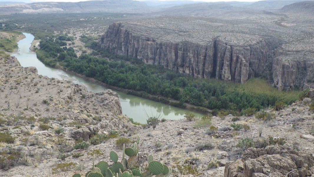
The Rio Grande River here looks MUCH different than it does in Big Bend. Here, it is deeper, looks much cleaner, and is very wide. Here is a photo I took of a couple of houses in Mexico from the USA side of the river:
rgr2.JPG
 
Last edited:
I don't think the Texas Coral Snake likes rain nearly as much as the AZ species (most of the AZ coral snakes are found during or just after heavy summer rains--so not many people see them, yet they are fairly common). But the Texas Coral Snake does like moist places and when I was on this trail, I was thinking this would be a good place to see one. But no such luck.

snakesign.JPG


Here is what the area looks like, trails are level and very easy to hike on, but very easy to get lost because there are trails into more trails just about everywhere in the park. I always bring my hiking GPSes (two, so I have a backup) and mark many areas so I do not get totally lost.

trail2.JPGwatchdeck.JPG


Those who stay on the main paid roads in the park can get around by a tram that will pick up people. But I mostly stayed off the pavement and I would rather walk anyway.

-Don- Mission, TX
 
Interesting and different view of the Rio Grande river, I'm not used to seeing it like in your photo.

Where are you camped?

Thanks for sharing,
Ray
Yeah, I was also very surprised when I got to the river. Not what I expected to see. I've never seen the Rio Grande River anywhere anything like this.

I am in the RV resort right next to the park. To give you an idea how close I am to the park, the bus parking lot for the park is on the opposite side of the fence from this "RV Resort". This "RV Resort" is VERY large place, and perhaps around 85% of this RV Resort is empty. Very few RVs here. But a worker told me by January, this place will be totally full with the snowbirds. There are many other RV parks in this area, so I assume this area is a popular place for snowbirds.

This is a very nice RV resort. And large enough to get lost in. Even has a hobby / wood shop for people to make and design stuff. But I have not yet checked it out. I really don't care about all the resort stuff, I just like the location here. There are even many hikes around here outside the park. Many trails.

BTW, I will go back into the park later this week (I could even stay here longer than a week to make up for time lost from 3 days of mostly nonstop rain). I only have my motorcycle with me, so I was trapped in my RV for three days and nights.

When I go back in the park, it will be for the entire day, I will bring food and water, unlike today when I was only planning a very short hike but spent a couple of hours in there anyway.

-Don- Mission, TX 78572
 
Here is what the area looks like, trails are level and very easy to hike on, but very easy to get lost because there are trails into more trails just about everywhere in the park. I always bring my hiking GPSes (two, so I have a backup) and mark many areas so I do not get totally lost.

Getting lost can happen quick. My kid and I were hunting and he penetrated a hedge to get to another area. I chose to go around the hedge - about 200 feet around. On the other side was heavily brushed and we instantly lost contact with each other.

Both our GPSs died and we didn't find each other until we got back to the car after dark. I knew the general direction but I neve did find the original trail head. We both had flashlights and plenty of water.

The next week we got an area topographical map and a compass and picked 3 waypoints (lakes and ponds) to find without use of electronics. I had not in the past carried a compass on my hunting rig. We hiked about 5 hours using only orienteering skills. It was good practice.
 
Is the water really blue like the picture looks?

Glad the rain is over down there. I'll try to get back tomorrow to see more pics.
 
Let me guess . . .you didn't bring spare batteries.

-Don- Mission, TX
They were phones...

Just as dumb we had handhelds, they also died. They were multi-power and had we carried AAs we could have changed out the rechargeable batteries.

Now my rig has a compass and spare AAs. I also carry some kind of map of appropriate scale if there is any chance we will get lost or plan a long day.
 
Is the water really blue like the picture looks?
Yep, just like in my photo. Looks very different than the same river up north (in Big Bend Nat'l Park--<from same camera, but before I had the date activated to show>):

BBT.jpg


-Don-
 
They were phones...
I avoid those phones as much as possible and use real GPS units. Garmin and Delorme PN60 for hiking. I have three hiking GPS units with me now, a Garmin 60CS Garmin 64S and a Delorme PN-60 ( I also own a few others):

81i30upf1YL._AC_SL1500_.jpg

81BBUUWf5uL._AC_SL1500_.jpg

41KGi+zHulL._AC_.jpg


-Don- Mission, TX
 
I avoid those phones as much as possible and use real GPS units. Garmin and Delorme PN60 for hiking.
Probably a good idea but my kid already thinks I am nuts with all the stuff I carry on my hunting rig. It is true that battery life for a phone when gps tracking can be pretty short.
 
Get a external power pack to plug into the phone to recharge it.

I have one that is 20K or so. will recharge the phone three or four times. I have a home made one, a little bulky to be carrying around, that I use on my workshop bench to keep the phone topped off out there. Uses Makita 18v battery. Workbench is freestanding and no power to it. This was playing around with left over bits and pieces. (yes, all of my batteries are numbered and dated as to when they were put into service)

Charles
 

Attachments

  • front view showing USB power station ports.jpg
    front view showing USB power station ports.jpg
    300.8 KB · Views: 2
I took a hike in the park again today.

Here is what the overnight campground looks like:
campground.JPG
Here are some photos of the Hawk Tower:
Hawktower.JPGhawktower3.JPG
The View from the end of Hawk Tower
hawktview.JPG
 
We have a couple of powerbanks. They are about the size of a mobile phone. I had left ours in truck for 6 months and it was still charged when we got back!
 
Another thing to carry - LOL... I do have one I carry in my computer bag.
While most people try for light weight, I usually carry as much stuff as possible. I figure I am out there to get some exercise anyway. When I used to go backpacking, I didn't try to keep the weight down. The bigger problem was getting enough stuff in the pack for more than a week trip. And I always carried the largest backpack possible.

-Don- Mission, TX
 

Latest posts

Forum statistics

Threads
131,988
Posts
1,388,711
Members
137,736
Latest member
Savysoaker
Back
Top Bottom